Oberlascheid geodata
Oberlascheid (Rheinland-Pfalz) is a seat of a fourth-order administrative division; located in Germany in Europe/Berlin (GMT+2) time zone. With population of 140 people, there are 10724 cities with bigger population in this country. Compared to other cities in Germany, 57.9% of cities are located further ↑North; 99.2% of cities are located further →East and 88.9% of cities have lower elevation than Oberlascheid. Note1
Administrative division(s):
- Level 1: Rheinland-Pfalz
- Level 3: Eifelkreis Bitburg-Prüm
- Level 4: Oberlascheid


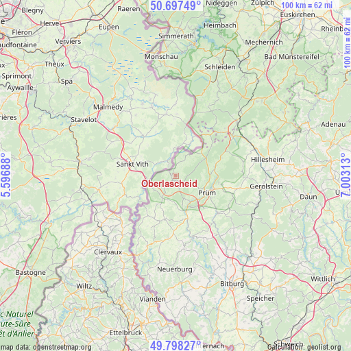
Oberlascheid GPS coordinates[2]
50° 15' 0" North, 6° 18' 0" East
| Map corner | latitude | longitude |
|---|---|---|
| Upper-left | 50.69749°, | 5.59688° |
| Center: | 50.25°, | 6.3° |
| Lower-right: | 49.79827°, | 7.00313° |
| Map W x H: | 100×100 km | = 62.1×62.1mi |
| max Lat: | 55.01917° ⇑57.9% North |
| Oberlascheid: | 50.25° |
| min Lat: | ⇓42.1% South 47.40724° |
| min Long | Oberlascheid | max Long |
| 5.92978° | 6.3° | 14.98853° |
| W 0.8%⇐ | ⇒99.2% E |
Elevation
Elevation of Oberlascheid is 503 m = 1650 ft, and this is 253.9 m = 833 ft above average elevation for this country.
| Max E: |
1256 m = 4121 ft | 11.1% |
| Oberlascheid | 503 m 1650 ft | |
| Avg. | 249.1 m = 817 ft | |
Min E: |
-5 m = -16 ft | 88.9% |
See also: Germany elevation on elevation.city.
Geographical zone
Oberlascheid is located in North temperate zone (between Tropic of Cancer and the Arctic Circle). Distance of this North polar circle is 1813.9 km =1127.1 mi to North.| Distance of | km | miles | from Oberlascheid |
|---|---|---|---|
| North Pole | 4419.8 | 2746.3 | to North |
| Arctic Circle | 1813.9 | 1127.1 | to North |
| Tropic Cancer | 2981.4 | 1852.6 | to South |
| Equator | 5587.3 | 3471.8 | to South |


Nearby cities:
15 places around Oberlascheid: (largest is in red/bold)
• Auw
6.3 km =3.9 mi,  25°
25°
• Bleialf
2.2 km =1.4 mi,  212°
212°
• Brandscheid
3.4 km =2.1 mi,  169°
169°
• Buchet
2.2 km =1.4 mi,  147°
147°
• Gondenbrett
8.5 km =5.3 mi,  102°
102°
• Großlangenfeld
5.1 km =3.2 mi,  223°
223°
• Habscheid
7.8 km =4.8 mi,  197°
197°
• Heckhuscheid
9.6 km =6 mi, 214°
• Mützenich
2.4 km =1.5 mi,  270°
270°
• Pittenbach
8.2 km =5.1 mi, 154°
• Prüm
9.7 km =6 mi,  118°
118°
• Sellerich
5.1 km =3.2 mi,  111°
111°
• Watzerath
8.8 km =5.5 mi, 147°
• Winterscheid
4 km =2.5 mi,  242°
242°
• Winterspelt
7 km =4.3 mi, 237°
Sources, notices
• [Note1] Compared only with cities in Germany existing in our database
• [Src1] Map data: © OpenStreetMap contributors (CC-BY-SA)
• [Src2] Other city data from geonames.org with taken over terms of usage.
• [Src3] Geographical zone / Annual Mean Temperature by Robert A. Rohde @ Wikipedia
