Niederwerrn geodata
Niederwerrn (Bavaria) is a seat of a fourth-order administrative division; located in Germany in Europe/Berlin (GMT+2) time zone. With population of 7,974 people, there are 1960 cities with bigger population in this country. Compared to other cities in Germany, 62.3% of cities are located further ↑North; 53% of cities are located further ←West and 52.9% of cities have lower elevation than Niederwerrn. Note1
Administrative division(s):
- Level 1: Bavaria
- Level 2: Regierungsbezirk Unterfranken
- Level 3: Landkreis Schweinfurt
- Level 4: Niederwerrn


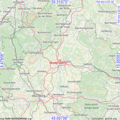
Niederwerrn GPS coordinates[2]
50° 3' 41.364" North, 10° 10' 57.72" East
| Map corner | latitude | longitude |
|---|---|---|
| Upper-left | 50.51075°, | 9.47958° |
| Center: | 50.06149°, | 10.1827° |
| Lower-right: | 49.60798°, | 10.88583° |
| Map W x H: | 100.4×100.4 km | = 62.4×62.4mi |
| max Lat: | 55.01917° ⇑62.3% North |
| Niederwerrn: | 50.06149° |
| min Lat: | ⇓37.7% South 47.40724° |
| min Long | Niederwerrn | max Long |
| 5.92978° | 10.1827° | 14.98853° |
| W 53%⇐ | ⇒47% E |
Elevation
Elevation of Niederwerrn is 246 m = 807 ft, and this is 3.1 m = 10 ft below average elevation for this country.
| Max E: |
1256 m = 4121 ft | 47.1% |
| Avg. | 249.1 m = 817 ft | |
| Niederwerrn | 246 m = 807 ft | |
Min E: |
-5 m = -16 ft | 52.9% |
See also: Germany elevation on elevation.city.
Geographical zone
Niederwerrn is located in North temperate zone (between Tropic of Cancer and the Arctic Circle). Distance of this North polar circle is 1834.9 km =1140.2 mi to North.| Distance of | km | miles | from Niederwerrn |
|---|---|---|---|
| North Pole | 4440.7 | 2759.3 | to North |
| Arctic Circle | 1834.9 | 1140.2 | to North |
| Tropic Cancer | 2960.4 | 1839.5 | to South |
| Equator | 5566.3 | 3458.7 | to South |


Nearby cities:
15 places around Niederwerrn: (largest is in red/bold)
• Bergrheinfeld
5.7 km =3.5 mi,  181°
181°
• Dittelbrunn
2.9 km =1.8 mi,  65°
65°
• Euerbach
3.3 km =2.1 mi,  270°
270°
• Geldersheim
2.8 km =1.7 mi,  222°
222°
• Gochsheim
8.7 km =5.4 mi,  124°
124°
• Grafenrheinfeld
6.9 km =4.3 mi,  169°
169°
• Hausen
9.3 km =5.8 mi,  83°
83°
• Oerlenbach
10.5 km =6.5 mi,  340°
340°
• Poppenhausen
5.2 km =3.2 mi,  326°
326°
• Röthlein
9 km =5.6 mi,  164°
164°
• Schonungen
9 km =5.6 mi,  98°
98°
• Schwebheim
9.2 km =5.7 mi,  149°
149°
• Schweinfurt
3.1 km =1.9 mi, 115°
• Sennfeld
6.1 km =3.8 mi,  114°
114°
• Üchtelhausen
7 km =4.3 mi,  61°
61°
Sources, notices
• [Note1] Compared only with cities in Germany existing in our database
• [Src1] Map data: © OpenStreetMap contributors (CC-BY-SA)
• [Src2] Other city data from geonames.org with taken over terms of usage.
• [Src3] Geographical zone / Annual Mean Temperature by Robert A. Rohde @ Wikipedia
