Schweinfurt geodata
Schweinfurt (Bavaria) is a seat of a third-order administrative division; located in Germany in Europe/Berlin (GMT+2) time zone. With population of 54,012 people, there are 200 cities with bigger population in this country. Compared to other cities in Germany, 62.5% of cities are located further ↑North; 53.8% of cities are located further ←West and 50.6% of cities have lower elevation than Schweinfurt. Note1
Administrative division(s):
- Level 1: Bavaria
- Level 2: Regierungsbezirk Unterfranken
- Level 3: Kreisfreie Stadt Schweinfurt
- Level 4: Schweinfurt


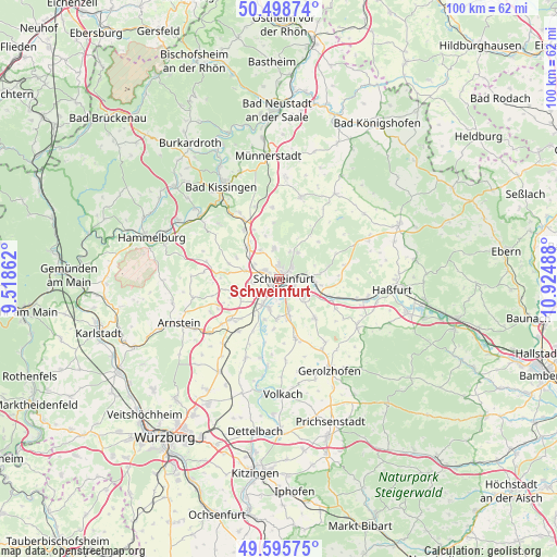
Schweinfurt GPS coordinates[2]
50° 2' 57.732" North, 10° 13' 18.3" East
| Map corner | latitude | longitude |
|---|---|---|
| Upper-left | 50.49874°, | 9.51862° |
| Center: | 50.04937°, | 10.22175° |
| Lower-right: | 49.59575°, | 10.92488° |
| Map W x H: | 100.4×100.4 km | = 62.4×62.4mi |
| max Lat: | 55.01917° ⇑62.5% North |
| Schweinfurt: | 50.04937° |
| min Lat: | ⇓37.5% South 47.40724° |
| min Long | Schweinfurt | max Long |
| 5.92978° | 10.22175° | 14.98853° |
| W 53.8%⇐ | ⇒46.2% E |
Elevation
Elevation of Schweinfurt is 230 m = 755 ft, and this is 19.1 m = 63 ft below average elevation for this country.
| Max E: |
1256 m = 4121 ft | 49.4% |
| Avg. | 249.1 m = 817 ft | |
| Schweinfurt | 230 m = 755 ft | |
Min E: |
-5 m = -16 ft | 50.6% |
See also: Schweinfurt elevation on elevation.city.
Geographical zone
Schweinfurt is located in North temperate zone (between Tropic of Cancer and the Arctic Circle). Distance of this North polar circle is 1836.2 km =1141 mi to North.| Distance of | km | miles | from Schweinfurt |
|---|---|---|---|
| North Pole | 4442.1 | 2760.2 | to North |
| Arctic Circle | 1836.2 | 1141 | to North |
| Tropic Cancer | 2959 | 1838.6 | to South |
| Equator | 5565 | 3457.9 | to South |


Nearby cities:
15 places around Schweinfurt: (largest is in red/bold)
• Bergrheinfeld
5.2 km =3.2 mi,  213°
213°
• Dittelbrunn
2.5 km =1.6 mi,  356°
356°
• Euerbach
6.2 km =3.9 mi,  283°
283°
• Geldersheim
4.7 km =2.9 mi,  261°
261°
• Gochsheim
5.7 km =3.5 mi,  129°
129°
• Grafenrheinfeld
5.7 km =3.5 mi,  195°
195°
• Gädheim
9.3 km =5.8 mi,  101°
101°
• Hausen
6.9 km =4.3 mi,  69°
69°
• Niederwerrn
3.1 km =1.9 mi,  295°
295°
• Poppenhausen
8 km =5 mi,  314°
314°
• Röthlein
7.4 km =4.6 mi,  182°
182°
• Schonungen
6.2 km =3.9 mi,  89°
89°
• Schwebheim
6.8 km =4.2 mi,  164°
164°
• Sennfeld
3 km =1.9 mi,  113°
113°
• Üchtelhausen
5.8 km =3.6 mi,  35°
35°
Sources, notices
• [Note1] Compared only with cities in Germany existing in our database
• [Src1] Map data: © OpenStreetMap contributors (CC-BY-SA)
• [Src2] Other city data from geonames.org with taken over terms of usage.
• [Src3] Geographical zone / Annual Mean Temperature by Robert A. Rohde @ Wikipedia
