Mosbruch geodata
Mosbruch (Rheinland-Pfalz) is a seat of a fourth-order administrative division; located in Germany in Europe/Berlin (GMT+2) time zone. With population of 170 people, there are 10595 cities with bigger population in this country. Compared to other cities in Germany, 57.5% of cities are located further ↑North; 94% of cities are located further →East and 92.3% of cities have lower elevation than Mosbruch. Note1


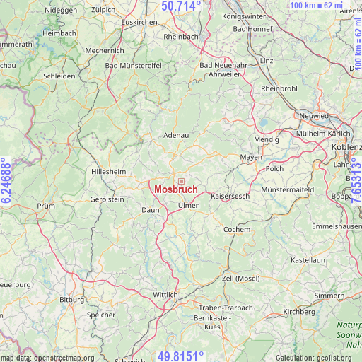
Mosbruch GPS coordinates[2]
50° 16' 0.012" North, 6° 57' 0" East
| Map corner | latitude | longitude |
|---|---|---|
| Upper-left | 50.714°, | 6.24688° |
| Center: | 50.26667°, | 6.95° |
| Lower-right: | 49.8151°, | 7.65313° |
| Map W x H: | 99.9×99.9 km | = 62.1×62.1mi |
| max Lat: | 55.01917° ⇑57.5% North |
| Mosbruch: | 50.26667° |
| min Lat: | ⇓42.5% South 47.40724° |
| min Long | Mosbruch | max Long |
| 5.92978° | 6.95° | 14.98853° |
| W 6%⇐ | ⇒94% E |
Elevation
Elevation of Mosbruch is 547 m = 1795 ft, and this is 297.9 m = 977 ft above average elevation for this country.
| Max E: |
1256 m = 4121 ft | 7.7% |
| Mosbruch | 547 m 1795 ft | |
| Avg. | 249.1 m = 817 ft | |
Min E: |
-5 m = -16 ft | 92.3% |
See also: Germany elevation on elevation.city.
Geographical zone
Mosbruch is located in North temperate zone (between Tropic of Cancer and the Arctic Circle). Distance of this North polar circle is 1812 km =1125.9 mi to North.| Distance of | km | miles | from Mosbruch |
|---|---|---|---|
| North Pole | 4417.9 | 2745.2 | to North |
| Arctic Circle | 1812 | 1125.9 | to North |
| Tropic Cancer | 2983.2 | 1853.7 | to South |
| Equator | 5589.1 | 3472.9 | to South |


Nearby cities:
15 places around Mosbruch: (largest is in red/bold)
• Bereborn
2.2 km =1.4 mi,  32°
32°
• Berenbach
3.7 km =2.3 mi,  180°
180°
• Gefell
4.4 km =2.7 mi,  212°
212°
• Gunderath
2.4 km =1.5 mi,  122°
122°
• Horperath
1.9 km =1.2 mi, 180°
• Höchstberg
4 km =2.5 mi, 117°
• Hörschhausen
2.2 km =1.4 mi, 212°
• Katzwinkel
3 km =1.9 mi,  231°
231°
• Kelberg
3.5 km =2.2 mi,  322°
322°
• Kolverath
1.2 km =0.7 mi,  90°
90°
• Kötterichen
3.8 km =2.4 mi,  140°
140°
• Mannebach
3 km =1.9 mi,  51°
51°
• Reimerath
3.9 km =2.4 mi,  17°
17°
• Sassen
1.2 km =0.7 mi, 90°
• Ueß
2.2 km =1.4 mi, 212°
Sources, notices
• [Note1] Compared only with cities in Germany existing in our database
• [Src1] Map data: © OpenStreetMap contributors (CC-BY-SA)
• [Src2] Other city data from geonames.org with taken over terms of usage.
• [Src3] Geographical zone / Annual Mean Temperature by Robert A. Rohde @ Wikipedia
