Höchstberg geodata
Höchstberg (Rheinland-Pfalz) is a seat of a fourth-order administrative division; located in Germany in Europe/Berlin (GMT+2) time zone. With population of 410 people, there are 9661 cities with bigger population in this country. Compared to other cities in Germany, 57.9% of cities are located further ↑North; 93.4% of cities are located further →East and 84.3% of cities have lower elevation than Höchstberg. Note1


Höchstberg GPS coordinates[2]
50° 15' 0" North, 7° 0' 0" East
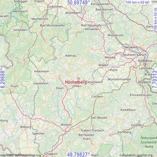
| Map corner | latitude | longitude |
|---|---|---|
| Upper-left | 50.69749°, | 6.29688° |
| Center: | 50.25°, | 7° |
| Lower-right: | 49.79827°, | 7.70313° |
| Map W x H: | 100×100 km | = 62.1×62.1mi |
| max Lat: | 55.01917° ⇑57.9% North |
| Höchstberg: | 50.25° |
| min Lat: | ⇓42.1% South 47.40724° |
| min Long | Höchstberg | max Long |
| 5.92978° | 7° | 14.98853° |
| W 6.6%⇐ | ⇒93.4% E |
Elevation
Elevation of Höchstberg is 463 m = 1519 ft, and this is 213.9 m = 702 ft above average elevation for this country.
| Max E: |
1256 m = 4121 ft | 15.7% |
| Höchstberg | 463 m 1519 ft | |
| Avg. | 249.1 m = 817 ft | |
Min E: |
-5 m = -16 ft | 84.3% |
See also: Germany elevation on elevation.city.
Geographical zone
Höchstberg is located in North temperate zone (between Tropic of Cancer and the Arctic Circle). Distance of this North polar circle is 1813.9 km =1127.1 mi to North.| Distance of | km | miles | from Höchstberg |
|---|---|---|---|
| North Pole | 4419.8 | 2746.3 | to North |
| Arctic Circle | 1813.9 | 1127.1 | to North |
| Tropic Cancer | 2981.4 | 1852.6 | to South |
| Equator | 5587.3 | 3471.8 | to South |


Nearby cities:
15 places around Höchstberg: (largest is in red/bold)
• Bereborn
4.4 km =2.7 mi,  327°
327°
• Berenbach
4 km =2.5 mi,  242°
242°
• Eppenberg
4.7 km =2.9 mi,  90°
90°
• Gunderath
1.6 km =1 mi,  290°
290°
• Horperath
3.6 km =2.2 mi,  270°
270°
• Kaperich
2.4 km =1.5 mi, 90°
• Kolverath
3 km =1.9 mi,  308°
308°
• Kötterichen
1.6 km =1 mi,  225°
225°
• Lirstal
2.4 km =1.5 mi, 90°
• Mannebach
3.9 km =2.4 mi,  342°
342°
• Mosbruch
4 km =2.5 mi,  297°
297°
• Oberelz
4 km =2.5 mi,  62°
62°
• Retterath
2.2 km =1.4 mi,  32°
32°
• Sassen
3 km =1.9 mi, 308°
• Uersfeld
1.2 km =0.7 mi, 90°
Sources, notices
• [Note1] Compared only with cities in Germany existing in our database
• [Src1] Map data: © OpenStreetMap contributors (CC-BY-SA)
• [Src2] Other city data from geonames.org with taken over terms of usage.
• [Src3] Geographical zone / Annual Mean Temperature by Robert A. Rohde @ Wikipedia
