Monstab geodata
Monstab (Thuringia) is a seat of a fourth-order administrative division; located in Germany in Europe/Berlin (GMT+2) time zone. With population of 517 people, there are 9276 cities with bigger population in this country. Compared to other cities in Germany, 58.1% of cities are located further ↓South; 86.3% of cities are located further ←West and 54.9% of cities have higher elevation than Monstab. Note1


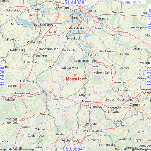
Monstab GPS coordinates[2]
51° 0' 0" North, 12° 21' 0" East
| Map corner | latitude | longitude |
|---|---|---|
| Upper-left | 51.44038°, | 11.64688° |
| Center: | 51°, | 12.35° |
| Lower-right: | 50.5554°, | 13.05313° |
| Map W x H: | 98.4×98.4 km | = 61.1×61.1mi |
| max Lat: | 55.01917° ⇑41.9% North |
| Monstab: | 51° |
| min Lat: | ⇓58.1% South 47.40724° |
| min Long | Monstab | max Long |
| 5.92978° | 12.35° | 14.98853° |
| W 86.3%⇐ | ⇒13.7% E |
Elevation
Elevation of Monstab is 190 m = 623 ft, and this is 59.1 m = 194 ft below average elevation for this country.
| Max E: |
1256 m = 4121 ft | 54.9% |
| Avg. | 249.1 m = 817 ft | |
| Monstab | 190 m = 623 ft | |
Min E: |
-5 m = -16 ft | 45.1% |
See also: Germany elevation on elevation.city.
Geographical zone
Monstab is located in North temperate zone (between Tropic of Cancer and the Arctic Circle). Distance of this North polar circle is 1730.5 km =1075.3 mi to North.| Distance of | km | miles | from Monstab |
|---|---|---|---|
| North Pole | 4336.4 | 2694.5 | to North |
| Arctic Circle | 1730.5 | 1075.3 | to North |
| Tropic Cancer | 3064.7 | 1904.3 | to South |
| Equator | 5670.7 | 3523.6 | to South |


Nearby cities:
15 places around Monstab: (largest is in red/bold)
• Altenburg
6.2 km =3.9 mi,  102°
102°
• Altkirchen
7.4 km =4.6 mi,  180°
180°
• Dobitschen
6.8 km =4.2 mi,  225°
225°
• Gerstenberg
7 km =4.3 mi,  60°
60°
• Göhren
3.9 km =2.4 mi,  162°
162°
• Göllnitz
6.2 km =3.9 mi,  199°
199°
• Kayna
7.9 km =4.9 mi,  265°
265°
• Kriebitzsch
2.9 km =1.8 mi,  335°
335°
• Lumpzig
8.1 km =5 mi, 226°
• Lödla
2.3 km =1.4 mi,  90°
90°
• Mehna
4.4 km =2.7 mi,  212°
212°
• Meuselwitz
6 km =3.7 mi,  323°
323°
• Rositz
2.1 km =1.3 mi,  26°
26°
• Treben
7.3 km =4.5 mi,  39°
39°
• Wintersdorf
5.9 km =3.7 mi,  3°
3°
Sources, notices
• [Note1] Compared only with cities in Germany existing in our database
• [Src1] Map data: © OpenStreetMap contributors (CC-BY-SA)
• [Src2] Other city data from geonames.org with taken over terms of usage.
• [Src3] Geographical zone / Annual Mean Temperature by Robert A. Rohde @ Wikipedia
