Göllnitz geodata
Göllnitz (Thuringia) is a seat of a fourth-order administrative division; located in Germany in Europe/Berlin (GMT+2) time zone. With population of 391 people, there are 9719 cities with bigger population in this country. Compared to other cities in Germany, 57.1% of cities are located further ↓South; 86% of cities are located further ←West and 54.7% of cities have lower elevation than Göllnitz. Note1


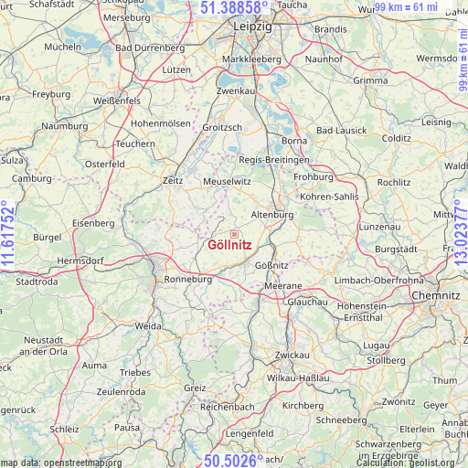
Göllnitz GPS coordinates[2]
50° 56' 51.72" North, 12° 19' 14.304" East
| Map corner | latitude | longitude |
|---|---|---|
| Upper-left | 51.38858°, | 11.61752° |
| Center: | 50.9477°, | 12.32064° |
| Lower-right: | 50.5026°, | 13.02377° |
| Map W x H: | 98.5×98.5 km | = 61.2×61.2mi |
| max Lat: | 55.01917° ⇑42.9% North |
| Göllnitz: | 50.9477° |
| min Lat: | ⇓57.1% South 47.40724° |
| min Long | Göllnitz | max Long |
| 5.92978° | 12.32064° | 14.98853° |
| W 86%⇐ | ⇒14% E |
Elevation
Elevation of Göllnitz is 256 m = 840 ft, and this is 6.9 m = 23 ft above average elevation for this country.
| Max E: |
1256 m = 4121 ft | 45.3% |
| Göllnitz | 256 m 840 ft | |
| Avg. | 249.1 m = 817 ft | |
Min E: |
-5 m = -16 ft | 54.7% |
See also: Germany elevation on elevation.city.
Geographical zone
Göllnitz is located in North temperate zone (between Tropic of Cancer and the Arctic Circle). Distance of this North polar circle is 1736.3 km =1078.9 mi to North.| Distance of | km | miles | from Göllnitz |
|---|---|---|---|
| North Pole | 4342.2 | 2698.1 | to North |
| Arctic Circle | 1736.3 | 1078.9 | to North |
| Tropic Cancer | 3058.9 | 1900.7 | to South |
| Equator | 5664.9 | 3520 | to South |


Nearby cities:
15 places around Göllnitz: (largest is in red/bold)
• Altkirchen
2.6 km =1.6 mi,  127°
127°
• Dobitschen
3 km =1.9 mi,  290°
290°
• Drogen
3.5 km =2.2 mi,  184°
184°
• Göhren
3.9 km =2.4 mi,  56°
56°
• Kayna
7.8 km =4.8 mi,  311°
311°
• Kriebitzsch
8.5 km =5.3 mi,  5°
5°
• Lumpzig
3.8 km =2.4 mi,  273°
273°
• Löbichau
7.2 km =4.5 mi,  213°
213°
• Lödla
7.3 km =4.5 mi,  37°
37°
• Mehna
2.1 km =1.3 mi,  352°
352°
• Monstab
6.2 km =3.9 mi,  19°
19°
• Rositz
8.3 km =5.2 mi, 21°
• Saara
7.2 km =4.5 mi,  103°
103°
• Schmölln
6.1 km =3.8 mi,  157°
157°
• Wildenbörten
4.3 km =2.7 mi,  217°
217°
Sources, notices
• [Note1] Compared only with cities in Germany existing in our database
• [Src1] Map data: © OpenStreetMap contributors (CC-BY-SA)
• [Src2] Other city data from geonames.org with taken over terms of usage.
• [Src3] Geographical zone / Annual Mean Temperature by Robert A. Rohde @ Wikipedia
