Monreal geodata
Monreal (Rheinland-Pfalz) is a seat of a fourth-order administrative division; located in Germany in Europe/Berlin (GMT+2) time zone. With population of 864 people, there are 7647 cities with bigger population in this country. Compared to other cities in Germany, 56.8% of cities are located further ↑North; 91.8% of cities are located further →East and 60.7% of cities have lower elevation than Monreal. Note1
Administrative division(s):
- Level 1: Rheinland-Pfalz
- Level 3: Landkreis Mayen-Koblenz
- Level 4: Monreal


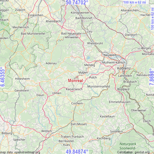
Monreal GPS coordinates[2]
50° 18' 0" North, 7° 10' 0.012" East
| Map corner | latitude | longitude |
|---|---|---|
| Upper-left | 50.74702°, | 6.46355° |
| Center: | 50.3°, | 7.16667° |
| Lower-right: | 49.84874°, | 7.8698° |
| Map W x H: | 99.9×99.9 km | = 62.1×62.1mi |
| max Lat: | 55.01917° ⇑56.8% North |
| Monreal: | 50.3° |
| min Lat: | ⇓43.2% South 47.40724° |
| min Long | Monreal | max Long |
| 5.92978° | 7.16667° | 14.98853° |
| W 8.2%⇐ | ⇒91.8% E |
Elevation
Elevation of Monreal is 294 m = 965 ft, and this is 44.9 m = 147 ft above average elevation for this country.
| Max E: |
1256 m = 4121 ft | 39.3% |
| Monreal | 294 m 965 ft | |
| Avg. | 249.1 m = 817 ft | |
Min E: |
-5 m = -16 ft | 60.7% |
See also: Germany elevation on elevation.city.
Geographical zone
Monreal is located in North temperate zone (between Tropic of Cancer and the Arctic Circle). Distance of this North polar circle is 1808.3 km =1123.6 mi to North.| Distance of | km | miles | from Monreal |
|---|---|---|---|
| North Pole | 4414.2 | 2742.9 | to North |
| Arctic Circle | 1808.3 | 1123.6 | to North |
| Tropic Cancer | 2986.9 | 1856 | to South |
| Equator | 5592.8 | 3475.2 | to South |


Nearby cities:
15 places around Monreal: (largest is in red/bold)
• Anschau
4.7 km =2.9 mi,  270°
270°
• Bermel
6.2 km =3.9 mi,  252°
252°
• Ditscheid
7.1 km =4.4 mi, 270°
• Düngenheim
4.4 km =2.7 mi,  181°
181°
• Ettringen
6.6 km =4.1 mi,  32°
32°
• Gering
7.3 km =4.5 mi,  104°
104°
• Hirten
6 km =3.7 mi,  308°
308°
• Kalenborn
7 km =4.3 mi,  237°
237°
• Kehrig
4 km =2.5 mi,  117°
117°
• Luxem
6 km =3.7 mi, 308°
• Mayen
5.1 km =3.2 mi,  52°
52°
• Reudelsterz
2.2 km =1.4 mi,  327°
327°
• Sankt Johann
6 km =3.7 mi,  23°
23°
• Urmersbach
6 km =3.7 mi,  203°
203°
• Weiler
4 km =2.5 mi,  297°
297°
Sources, notices
• [Note1] Compared only with cities in Germany existing in our database
• [Src1] Map data: © OpenStreetMap contributors (CC-BY-SA)
• [Src2] Other city data from geonames.org with taken over terms of usage.
• [Src3] Geographical zone / Annual Mean Temperature by Robert A. Rohde @ Wikipedia
