Meggerdorf geodata
Meggerdorf (Schleswig-Holstein) is a seat of a fourth-order administrative division; located in Germany in Europe/Berlin (GMT+2) time zone. With population of 701 people, there are 8308 cities with bigger population in this country. Compared to other cities in Germany, 96.8% of cities are located further ↓South; 59.3% of cities are located further →East and 99.5% of cities have higher elevation than Meggerdorf. Note1
Administrative division(s):
- Level 1: Schleswig-Holstein
- Level 3: Kreis Schleswig-Flensburg
- Level 4: Meggerdorf


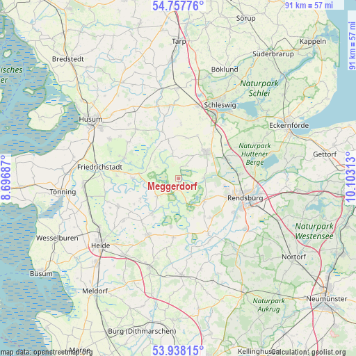
Meggerdorf GPS coordinates[2]
54° 21' 0" North, 9° 24' 0" East
| Map corner | latitude | longitude |
|---|---|---|
| Upper-left | 54.75776°, | 8.69687° |
| Center: | 54.35°, | 9.4° |
| Lower-right: | 53.93815°, | 10.10313° |
| Map W x H: | 91.1×91.1 km | = 56.6×56.6mi |
| max Lat: | 55.01917° ⇑3.2% North |
| Meggerdorf: | 54.35° |
| min Lat: | ⇓96.8% South 47.40724° |
| min Long | Meggerdorf | max Long |
| 5.92978° | 9.4° | 14.98853° |
| W 40.7%⇐ | ⇒59.3% E |
Elevation
Elevation of Meggerdorf is -1 m = -3 ft, and this is 250.1 m = 821 ft below average elevation for this country.
| Max E: |
1256 m = 4121 ft | 99.5% |
| Avg. | 249.1 m = 817 ft | |
| Meggerdorf | -1 m = -3 ft | |
Min E: |
-5 m = -16 ft | 0.5% |
See also: Germany elevation on elevation.city.
Geographical zone
Meggerdorf is located in North temperate zone (between Tropic of Cancer and the Arctic Circle). Distance of this North polar circle is 1358 km =843.8 mi to North.| Distance of | km | miles | from Meggerdorf |
|---|---|---|---|
| North Pole | 3963.9 | 2463.1 | to North |
| Arctic Circle | 1358 | 843.8 | to North |
| Tropic Cancer | 3437.2 | 2135.8 | to South |
| Equator | 6043.2 | 3755.1 | to South |


Nearby cities:
15 places around Meggerdorf: (largest is in red/bold)
• Alt Bennebek
4.3 km =2.7 mi,  30°
30°
• Bergenhusen
6.5 km =4 mi,  304°
304°
• Börm
5.7 km =3.5 mi,  349°
349°
• Christiansholm
3.9 km =2.4 mi,  163°
163°
• Erfde
7.8 km =4.8 mi,  224°
224°
• Friedrichsgraben
9.3 km =5.8 mi,  173°
173°
• Friedrichsholm
5.7 km =3.5 mi, 161°
• Hohn
8.5 km =5.3 mi,  130°
130°
• Klein Bennebek
6.4 km =4 mi, 30°
• Königshügel
4.7 km =2.9 mi,  113°
113°
• Lohe-Föhrden
8.8 km =5.5 mi,  102°
102°
• Sophienhamm
8.6 km =5.3 mi,  149°
149°
• Tetenhusen
6.5 km =4 mi,  90°
90°
• Tielen
8.6 km =5.3 mi,  210°
210°
• Wohlde
9 km =5.6 mi,  313°
313°
Sources, notices
• [Note1] Compared only with cities in Germany existing in our database
• [Src1] Map data: © OpenStreetMap contributors (CC-BY-SA)
• [Src2] Other city data from geonames.org with taken over terms of usage.
• [Src3] Geographical zone / Annual Mean Temperature by Robert A. Rohde @ Wikipedia
