Friedrichsholm geodata
Friedrichsholm (Schleswig-Holstein) is a seat of a fourth-order administrative division; located in Germany in Europe/Berlin (GMT+2) time zone. With population of 473 people, there are 9465 cities with bigger population in this country. Compared to other cities in Germany, 96.3% of cities are located further ↓South; 58.9% of cities are located further →East and 94.8% of cities have higher elevation than Friedrichsholm. Note1
Administrative division(s):
- Level 1: Schleswig-Holstein
- Level 3: Kreis Rendsburg-Eckernförde
- Level 4: Friedrichsholm


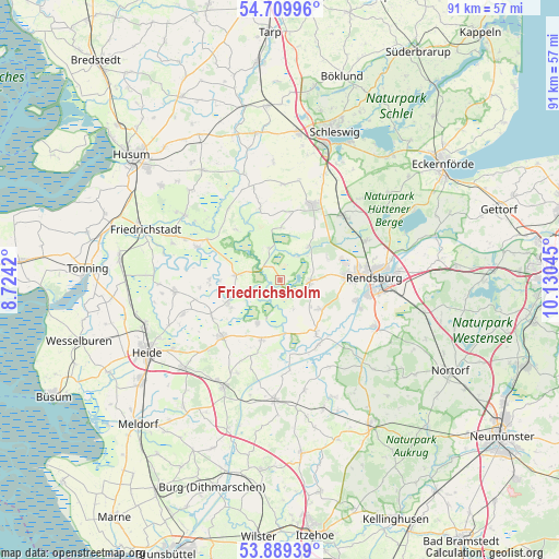
Friedrichsholm GPS coordinates[2]
54° 18' 6.192" North, 9° 25' 38.352" East
| Map corner | latitude | longitude |
|---|---|---|
| Upper-left | 54.70996°, | 8.7242° |
| Center: | 54.30172°, | 9.42732° |
| Lower-right: | 53.88939°, | 10.13045° |
| Map W x H: | 91.2×91.2 km | = 56.7×56.7mi |
| max Lat: | 55.01917° ⇑3.7% North |
| Friedrichsholm: | 54.30172° |
| min Lat: | ⇓96.3% South 47.40724° |
| min Long | Friedrichsholm | max Long |
| 5.92978° | 9.42732° | 14.98853° |
| W 41.1%⇐ | ⇒58.9% E |
Elevation
Elevation of Friedrichsholm is 9 m = 30 ft, and this is 240.1 m = 788 ft below average elevation for this country.
| Max E: |
1256 m = 4121 ft | 94.8% |
| Avg. | 249.1 m = 817 ft | |
| Friedrichsholm | 9 m = 30 ft | |
Min E: |
-5 m = -16 ft | 5.2% |
See also: Germany elevation on elevation.city.
Geographical zone
Friedrichsholm is located in North temperate zone (between Tropic of Cancer and the Arctic Circle). Distance of this North polar circle is 1363.4 km =847.2 mi to North.| Distance of | km | miles | from Friedrichsholm |
|---|---|---|---|
| North Pole | 3969.3 | 2466.4 | to North |
| Arctic Circle | 1363.4 | 847.2 | to North |
| Tropic Cancer | 3431.9 | 2132.5 | to South |
| Equator | 6037.8 | 3751.7 | to South |


Nearby cities:
15 places around Friedrichsholm: (largest is in red/bold)
• Alt Bennebek
9.1 km =5.7 mi,  2°
2°
• Bargstall
4.7 km =2.9 mi,  146°
146°
• Christiansholm
1.8 km =1.1 mi,  337°
337°
• Dellstedt
8.6 km =5.3 mi,  207°
207°
• Elsdorf-Westermühlen
7 km =4.3 mi,  123°
123°
• Erfde
7.2 km =4.5 mi,  268°
268°
• Friedrichsgraben
4 km =2.5 mi,  190°
190°
• Hohn
4.7 km =2.9 mi,  92°
92°
• Königshügel
4.3 km =2.7 mi,  35°
35°
• Lohe-Föhrden
7.7 km =4.8 mi,  62°
62°
• Meggerdorf
5.7 km =3.5 mi, 341°
• Pahlen
9.1 km =5.7 mi,  244°
244°
• Sophienhamm
3.3 km =2.1 mi,  128°
128°
• Tetenhusen
7.1 km =4.4 mi, 41°
• Tielen
6.4 km =4 mi,  251°
251°
Sources, notices
• [Note1] Compared only with cities in Germany existing in our database
• [Src1] Map data: © OpenStreetMap contributors (CC-BY-SA)
• [Src2] Other city data from geonames.org with taken over terms of usage.
• [Src3] Geographical zone / Annual Mean Temperature by Robert A. Rohde @ Wikipedia
