Marzhausen geodata
Marzhausen (Rheinland-Pfalz) is a seat of a fourth-order administrative division; located in Germany in Europe/Berlin (GMT+2) time zone. With population of 258 people, there are 10221 cities with bigger population in this country. Compared to other cities in Germany, 51.8% of cities are located further ↓South; 81.9% of cities are located further →East and 63.7% of cities have lower elevation than Marzhausen. Note1


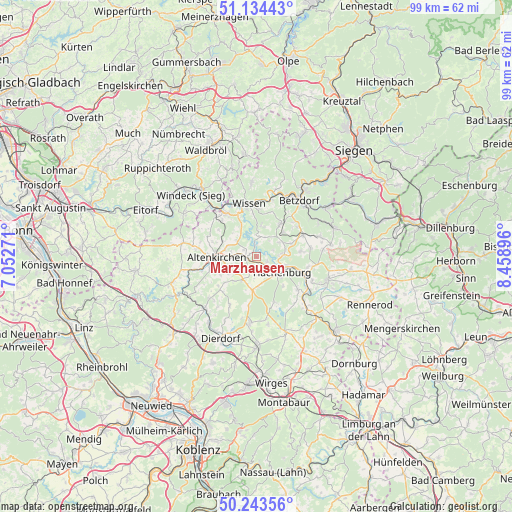
Marzhausen GPS coordinates[2]
50° 41' 27.996" North, 7° 45' 20.988" East
| Map corner | latitude | longitude |
|---|---|---|
| Upper-left | 51.13443°, | 7.05271° |
| Center: | 50.69111°, | 7.75583° |
| Lower-right: | 50.24356°, | 8.45896° |
| Map W x H: | 99.1×99.1 km | = 61.6×61.6mi |
| max Lat: | 55.01917° ⇑48.2% North |
| Marzhausen: | 50.69111° |
| min Lat: | ⇓51.8% South 47.40724° |
| min Long | Marzhausen | max Long |
| 5.92978° | 7.75583° | 14.98853° |
| W 18.1%⇐ | ⇒81.9% E |
Elevation
Elevation of Marzhausen is 313 m = 1027 ft, and this is 63.9 m = 210 ft above average elevation for this country.
| Max E: |
1256 m = 4121 ft | 36.3% |
| Marzhausen | 313 m 1027 ft | |
| Avg. | 249.1 m = 817 ft | |
Min E: |
-5 m = -16 ft | 63.7% |
See also: Germany elevation on elevation.city.
Geographical zone
Marzhausen is located in North temperate zone (between Tropic of Cancer and the Arctic Circle). Distance of this North polar circle is 1764.9 km =1096.7 mi to North.| Distance of | km | miles | from Marzhausen |
|---|---|---|---|
| North Pole | 4370.7 | 2715.8 | to North |
| Arctic Circle | 1764.9 | 1096.7 | to North |
| Tropic Cancer | 3030.4 | 1883 | to South |
| Equator | 5636.3 | 3502.2 | to South |


Nearby cities:
15 places around Marzhausen: (largest is in red/bold)
• Astert
1.6 km =1 mi,  74°
74°
• Borod
4.2 km =2.6 mi,  231°
231°
• Giesenhausen
2.9 km =1.8 mi,  289°
289°
• Hattert
2.8 km =1.7 mi,  164°
164°
• Heuzert
0.9 km =0.6 mi,  17°
17°
• Idelberg
4 km =2.5 mi,  315°
315°
• Ingelbach
3.5 km =2.2 mi,  255°
255°
• Kroppach
1.2 km =0.7 mi, 294°
• Kundert
4 km =2.5 mi,  39°
39°
• Limbach
3.3 km =2.1 mi, 72°
• Mudenbach
3.1 km =1.9 mi,  210°
210°
• Mörsbach
4.4 km =2.7 mi,  26°
26°
• Müschenbach
2.1 km =1.3 mi,  114°
114°
• Stein-Wingert
3.6 km =2.2 mi,  343°
343°
• Streithausen
4.2 km =2.6 mi,  86°
86°
Sources, notices
• [Note1] Compared only with cities in Germany existing in our database
• [Src1] Map data: © OpenStreetMap contributors (CC-BY-SA)
• [Src2] Other city data from geonames.org with taken over terms of usage.
• [Src3] Geographical zone / Annual Mean Temperature by Robert A. Rohde @ Wikipedia
