Mörsbach geodata
Mörsbach (Rheinland-Pfalz) is a seat of a fourth-order administrative division; located in Germany in Europe/Berlin (GMT+2) time zone. With population of 502 people, there are 9363 cities with bigger population in this country. Compared to other cities in Germany, 52.8% of cities are located further ↓South; 81.3% of cities are located further →East and 71.3% of cities have lower elevation than Mörsbach. Note1


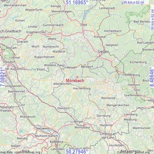
Mörsbach GPS coordinates[2]
50° 43' 36.012" North, 7° 46' 59.988" East
| Map corner | latitude | longitude |
|---|---|---|
| Upper-left | 51.16965°, | 7.08021° |
| Center: | 50.72667°, | 7.78333° |
| Lower-right: | 50.27946°, | 8.48646° |
| Map W x H: | 99×99 km | = 61.5×61.5mi |
| max Lat: | 55.01917° ⇑47.2% North |
| Mörsbach: | 50.72667° |
| min Lat: | ⇓52.8% South 47.40724° |
| min Long | Mörsbach | max Long |
| 5.92978° | 7.78333° | 14.98853° |
| W 18.7%⇐ | ⇒81.3% E |
Elevation
Elevation of Mörsbach is 368 m = 1207 ft, and this is 118.9 m = 390 ft above average elevation for this country.
| Max E: |
1256 m = 4121 ft | 28.7% |
| Mörsbach | 368 m 1207 ft | |
| Avg. | 249.1 m = 817 ft | |
Min E: |
-5 m = -16 ft | 71.3% |
See also: Germany elevation on elevation.city.
Geographical zone
Mörsbach is located in North temperate zone (between Tropic of Cancer and the Arctic Circle). Distance of this North polar circle is 1760.9 km =1094.2 mi to North.| Distance of | km | miles | from Mörsbach |
|---|---|---|---|
| North Pole | 4366.8 | 2713.4 | to North |
| Arctic Circle | 1760.9 | 1094.2 | to North |
| Tropic Cancer | 3034.4 | 1885.5 | to South |
| Equator | 5640.3 | 3504.7 | to South |


Nearby cities:
15 places around Mörsbach: (largest is in red/bold)
• Astert
3.5 km =2.2 mi,  185°
185°
• Atzelgift
4.6 km =2.9 mi,  130°
130°
• Elben
4.4 km =2.7 mi,  53°
53°
• Fensdorf
1.4 km =0.9 mi,  302°
302°
• Gebhardshain
3.5 km =2.2 mi,  42°
42°
• Helmeroth
3.6 km =2.2 mi,  281°
281°
• Heuzert
3.5 km =2.2 mi,  208°
208°
• Kroppach
4.6 km =2.9 mi,  221°
221°
• Kundert
1.1 km =0.7 mi,  145°
145°
• Limbach
3.2 km =2 mi,  158°
158°
• Luckenbach
4.6 km =2.9 mi, 130°
• Marzhausen
4.4 km =2.7 mi, 206°
• Selbach
2.4 km =1.5 mi,  337°
337°
• Stein-Wingert
3 km =1.9 mi,  261°
261°
• Streithausen
4.3 km =2.7 mi, 148°
Sources, notices
• [Note1] Compared only with cities in Germany existing in our database
• [Src1] Map data: © OpenStreetMap contributors (CC-BY-SA)
• [Src2] Other city data from geonames.org with taken over terms of usage.
• [Src3] Geographical zone / Annual Mean Temperature by Robert A. Rohde @ Wikipedia
