Maihingen geodata
Maihingen (Bavaria) is a seat of a fourth-order administrative division; located in Germany in Europe/Berlin (GMT+2) time zone. With population of 1,244 people, there are 6463 cities with bigger population in this country. Compared to other cities in Germany, 83.8% of cities are located further ↑North; 58.9% of cities are located further ←West and 79.3% of cities have lower elevation than Maihingen. Note1
Administrative division(s):
- Level 1: Bavaria
- Level 2: Swabia
- Level 3: Landkreis Donau-Ries
- Level 4: Maihingen


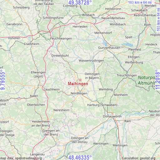
Maihingen GPS coordinates[2]
48° 55' 38.82" North, 10° 29' 55.212" East
| Map corner | latitude | longitude |
|---|---|---|
| Upper-left | 49.38728°, | 9.79555° |
| Center: | 48.92745°, | 10.49867° |
| Lower-right: | 48.46335°, | 11.2018° |
| Map W x H: | 102.7×102.7 km | = 63.8×63.8mi |
| max Lat: | 55.01917° ⇑83.8% North |
| Maihingen: | 48.92745° |
| min Lat: | ⇓16.2% South 47.40724° |
| min Long | Maihingen | max Long |
| 5.92978° | 10.49867° | 14.98853° |
| W 58.9%⇐ | ⇒41.1% E |
Elevation
Elevation of Maihingen is 429 m = 1407 ft, and this is 179.9 m = 590 ft above average elevation for this country.
| Max E: |
1256 m = 4121 ft | 20.7% |
| Maihingen | 429 m 1407 ft | |
| Avg. | 249.1 m = 817 ft | |
Min E: |
-5 m = -16 ft | 79.3% |
See also: Germany elevation on elevation.city.
Geographical zone
Maihingen is located in North temperate zone (between Tropic of Cancer and the Arctic Circle). Distance of this North polar circle is 1961 km =1218.5 mi to North.| Distance of | km | miles | from Maihingen |
|---|---|---|---|
| North Pole | 4566.8 | 2837.7 | to North |
| Arctic Circle | 1961 | 1218.5 | to North |
| Tropic Cancer | 2834.3 | 1761.2 | to South |
| Equator | 5440.2 | 3380.4 | to South |


Nearby cities:
15 places around Maihingen: (largest is in red/bold)
• Alerheim
12.2 km =7.6 mi,  134°
134°
• Deiningen
8.4 km =5.2 mi,  143°
143°
• Fremdingen
5.8 km =3.6 mi,  329°
329°
• Hainsfarth
9.8 km =6.1 mi,  69°
69°
• Kirchheim am Ries
9 km =5.6 mi,  233°
233°
• Marktoffingen
2 km =1.2 mi,  264°
264°
• Megesheim
11.1 km =6.9 mi,  86°
86°
• Munningen
7.5 km =4.7 mi,  99°
99°
• Nördlingen
8.5 km =5.3 mi,  184°
184°
• Oettingen in Bayern
8.2 km =5.1 mi, 70°
• Reimlingen
12.4 km =7.7 mi,  173°
173°
• Tannhausen
11.5 km =7.1 mi,  299°
299°
• Unterschneidheim
9.7 km =6 mi,  273°
273°
• Wallerstein
4.8 km =3 mi,  200°
200°
• Wechingen
9.2 km =5.7 mi,  115°
115°
Sources, notices
• [Note1] Compared only with cities in Germany existing in our database
• [Src1] Map data: © OpenStreetMap contributors (CC-BY-SA)
• [Src2] Other city data from geonames.org with taken over terms of usage.
• [Src3] Geographical zone / Annual Mean Temperature by Robert A. Rohde @ Wikipedia
