Lasbek geodata
Lasbek (Schleswig-Holstein) is a seat of a fourth-order administrative division; located in Germany in Europe/Berlin (GMT+2) time zone. With population of 1,162 people, there are 6670 cities with bigger population in this country. Compared to other cities in Germany, 89.1% of cities are located further ↓South; 56.6% of cities are located further ←West and 80.6% of cities have higher elevation than Lasbek. Note1


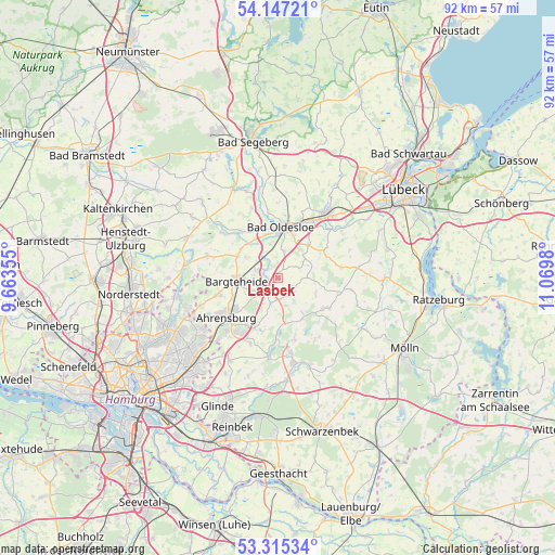
Lasbek GPS coordinates[2]
53° 43' 59.988" North, 10° 22' 0.012" East
| Map corner | latitude | longitude |
|---|---|---|
| Upper-left | 54.14721°, | 9.66355° |
| Center: | 53.73333°, | 10.36667° |
| Lower-right: | 53.31534°, | 11.0698° |
| Map W x H: | 92.5×92.5 km | = 57.5×57.5mi |
| max Lat: | 55.01917° ⇑10.9% North |
| Lasbek: | 53.73333° |
| min Lat: | ⇓89.1% South 47.40724° |
| min Long | Lasbek | max Long |
| 5.92978° | 10.36667° | 14.98853° |
| W 56.6%⇐ | ⇒43.4% E |
Elevation
Elevation of Lasbek is 45 m = 148 ft, and this is 204.1 m = 670 ft below average elevation for this country.
| Max E: |
1256 m = 4121 ft | 80.6% |
| Avg. | 249.1 m = 817 ft | |
| Lasbek | 45 m = 148 ft | |
Min E: |
-5 m = -16 ft | 19.4% |
See also: Germany elevation on elevation.city.
Geographical zone
Lasbek is located in North temperate zone (between Tropic of Cancer and the Arctic Circle). Distance of this North polar circle is 1426.6 km =886.4 mi to North.| Distance of | km | miles | from Lasbek |
|---|---|---|---|
| North Pole | 4032.5 | 2505.7 | to North |
| Arctic Circle | 1426.6 | 886.4 | to North |
| Tropic Cancer | 3368.7 | 2093.2 | to South |
| Equator | 5974.6 | 3712.4 | to South |


Nearby cities:
15 places around Lasbek: (largest is in red/bold)
• Bargteheide
6.6 km =4.1 mi,  265°
265°
• Delingsdorf
8.5 km =5.3 mi,  244°
244°
• Elmenhorst
7.5 km =4.7 mi,  299°
299°
• Groß Boden
5.8 km =3.6 mi,  71°
71°
• Hammoor
3.7 km =2.3 mi,  233°
233°
• Neritz
7.8 km =4.8 mi,  315°
315°
• Pölitz
4.5 km =2.8 mi,  13°
13°
• Rümpel
5.7 km =3.5 mi,  348°
348°
• Schiphorst
6.8 km =4.2 mi,  114°
114°
• Schönberg
6.8 km =4.2 mi,  144°
144°
• Schürensöhlen
8.5 km =5.3 mi,  64°
64°
• Steinhorst
7.9 km =4.9 mi,  103°
103°
• Stubben
4.4 km =2.7 mi,  90°
90°
• Todendorf
4.5 km =2.8 mi,  196°
196°
• Tremsbüttel
3.9 km =2.4 mi,  287°
287°
Sources, notices
• [Note1] Compared only with cities in Germany existing in our database
• [Src1] Map data: © OpenStreetMap contributors (CC-BY-SA)
• [Src2] Other city data from geonames.org with taken over terms of usage.
• [Src3] Geographical zone / Annual Mean Temperature by Robert A. Rohde @ Wikipedia
