Todendorf geodata
Todendorf (Schleswig-Holstein) is a seat of a fourth-order administrative division; located in Germany in Europe/Berlin (GMT+2) time zone. With population of 1,062 people, there are 6958 cities with bigger population in this country. Compared to other cities in Germany, 88.5% of cities are located further ↓South; 56.2% of cities are located further ←West and 79.4% of cities have higher elevation than Todendorf. Note1


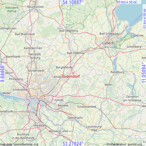
Todendorf GPS coordinates[2]
53° 41' 40.596" North, 10° 20' 52.116" East
| Map corner | latitude | longitude |
|---|---|---|
| Upper-left | 54.10887°, | 9.64468° |
| Center: | 53.69461°, | 10.34781° |
| Lower-right: | 53.27624°, | 11.05094° |
| Map W x H: | 92.6×92.6 km | = 57.5×57.5mi |
| max Lat: | 55.01917° ⇑11.5% North |
| Todendorf: | 53.69461° |
| min Lat: | ⇓88.5% South 47.40724° |
| min Long | Todendorf | max Long |
| 5.92978° | 10.34781° | 14.98853° |
| W 56.2%⇐ | ⇒43.8% E |
Elevation
Elevation of Todendorf is 48 m = 157 ft, and this is 201.1 m = 660 ft below average elevation for this country.
| Max E: |
1256 m = 4121 ft | 79.4% |
| Avg. | 249.1 m = 817 ft | |
| Todendorf | 48 m = 157 ft | |
Min E: |
-5 m = -16 ft | 20.6% |
See also: Germany elevation on elevation.city.
Geographical zone
Todendorf is located in North temperate zone (between Tropic of Cancer and the Arctic Circle). Distance of this North polar circle is 1430.9 km =889.1 mi to North.| Distance of | km | miles | from Todendorf |
|---|---|---|---|
| North Pole | 4036.8 | 2508.4 | to North |
| Arctic Circle | 1430.9 | 889.1 | to North |
| Tropic Cancer | 3364.4 | 2090.5 | to South |
| Equator | 5970.3 | 3709.8 | to South |


Nearby cities:
15 places around Todendorf: (largest is in red/bold)
• Ahrensburg
8.3 km =5.2 mi,  254°
254°
• Bargteheide
6.5 km =4 mi,  305°
305°
• Delingsdorf
6.5 km =4 mi,  275°
275°
• Großhansdorf
5.3 km =3.3 mi,  233°
233°
• Grönwohld
7.1 km =4.4 mi,  146°
146°
• Hammoor
2.7 km =1.7 mi,  321°
321°
• Hoisdorf
5.4 km =3.4 mi,  202°
202°
• Lasbek
4.5 km =2.8 mi,  16°
16°
• Lütjensee
5.1 km =3.2 mi,  165°
165°
• Schiphorst
7.6 km =4.7 mi,  78°
78°
• Schönberg
5.3 km =3.3 mi,  103°
103°
• Siek
7.5 km =4.7 mi, 204°
• Stubben
7.1 km =4.4 mi,  52°
52°
• Tremsbüttel
6 km =3.7 mi,  335°
335°
• Wentorf
8.6 km =5.3 mi, 104°
Sources, notices
• [Note1] Compared only with cities in Germany existing in our database
• [Src1] Map data: © OpenStreetMap contributors (CC-BY-SA)
• [Src2] Other city data from geonames.org with taken over terms of usage.
• [Src3] Geographical zone / Annual Mean Temperature by Robert A. Rohde @ Wikipedia
