Kutzleben geodata
Kutzleben (Thuringia) is a seat of a fourth-order administrative division; located in Germany in Europe/Berlin (GMT+2) time zone. With population of 722 people, there are 8225 cities with bigger population in this country. Compared to other cities in Germany, 61.5% of cities are located further ↓South; 63.2% of cities are located further ←West and 57% of cities have lower elevation than Kutzleben. Note1


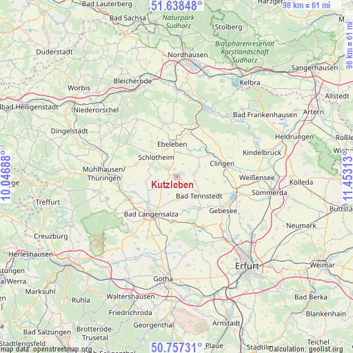
Kutzleben GPS coordinates[2]
51° 12' 0" North, 10° 45' 0" East
| Map corner | latitude | longitude |
|---|---|---|
| Upper-left | 51.63848°, | 10.04688° |
| Center: | 51.2°, | 10.75° |
| Lower-right: | 50.75731°, | 11.45313° |
| Map W x H: | 98×98 km | = 60.9×60.9mi |
| max Lat: | 55.01917° ⇑38.5% North |
| Kutzleben: | 51.2° |
| min Lat: | ⇓61.5% South 47.40724° |
| min Long | Kutzleben | max Long |
| 5.92978° | 10.75° | 14.98853° |
| W 63.2%⇐ | ⇒36.8% E |
Elevation
Elevation of Kutzleben is 272 m = 892 ft, and this is 22.9 m = 75 ft above average elevation for this country.
| Max E: |
1256 m = 4121 ft | 43% |
| Kutzleben | 272 m 892 ft | |
| Avg. | 249.1 m = 817 ft | |
Min E: |
-5 m = -16 ft | 57% |
See also: Germany elevation on elevation.city.
Geographical zone
Kutzleben is located in North temperate zone (between Tropic of Cancer and the Arctic Circle). Distance of this North polar circle is 1708.3 km =1061.5 mi to North.| Distance of | km | miles | from Kutzleben |
|---|---|---|---|
| North Pole | 4314.2 | 2680.7 | to North |
| Arctic Circle | 1708.3 | 1061.5 | to North |
| Tropic Cancer | 3087 | 1918.2 | to South |
| Equator | 5692.9 | 3537.4 | to South |


Nearby cities:
15 places around Kutzleben: (largest is in red/bold)
• Blankenburg
0 km =0 mi,  0°
0°
• Bruchstedt
3 km =1.9 mi,  128°
128°
• Freienbessingen
3.9 km =2.4 mi,  17°
17°
• Haussömmern
5 km =3.1 mi,  111°
111°
• Hornsömmern
5 km =3.1 mi,  68°
68°
• Kirchheilingen
3.5 km =2.2 mi,  235°
235°
• Kleinwelsbach
6.1 km =3.8 mi,  252°
252°
• Klettstedt
5.6 km =3.5 mi,  180°
180°
• Marolterode
5.9 km =3.7 mi,  308°
308°
• Mittelsömmern
4.6 km =2.9 mi,  90°
90°
• Neunheilingen
5.3 km =3.3 mi,  260°
260°
• Sundhausen
4.4 km =2.7 mi,  212°
212°
• Tottleben
3.7 km =2.3 mi, 180°
• Urleben
6 km =3.7 mi,  157°
157°
• Wolferschwenda
5.1 km =3.2 mi,  43°
43°
Sources, notices
• [Note1] Compared only with cities in Germany existing in our database
• [Src1] Map data: © OpenStreetMap contributors (CC-BY-SA)
• [Src2] Other city data from geonames.org with taken over terms of usage.
• [Src3] Geographical zone / Annual Mean Temperature by Robert A. Rohde @ Wikipedia
