Kükels geodata
Kükels (Schleswig-Holstein) is a seat of a fourth-order administrative division; located in Germany in Europe/Berlin (GMT+2) time zone. With population of 409 people, there are 9666 cities with bigger population in this country. Compared to other cities in Germany, 91.2% of cities are located further ↓South; 53.9% of cities are located further ←West and 84.5% of cities have higher elevation than Kükels. Note1


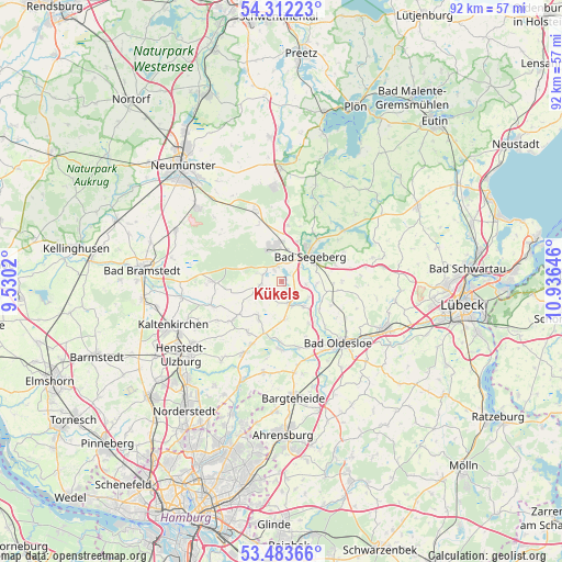
Kükels GPS coordinates[2]
53° 54' 0" North, 10° 13' 59.988" East
| Map corner | latitude | longitude |
|---|---|---|
| Upper-left | 54.31223°, | 9.5302° |
| Center: | 53.9°, | 10.23333° |
| Lower-right: | 53.48366°, | 10.93646° |
| Map W x H: | 92.1×92.1 km | = 57.2×57.2mi |
| max Lat: | 55.01917° ⇑8.8% North |
| Kükels: | 53.9° |
| min Lat: | ⇓91.2% South 47.40724° |
| min Long | Kükels | max Long |
| 5.92978° | 10.23333° | 14.98853° |
| W 53.9%⇐ | ⇒46.1% E |
Elevation
Elevation of Kükels is 36 m = 118 ft, and this is 213.1 m = 699 ft below average elevation for this country.
| Max E: |
1256 m = 4121 ft | 84.5% |
| Avg. | 249.1 m = 817 ft | |
| Kükels | 36 m = 118 ft | |
Min E: |
-5 m = -16 ft | 15.5% |
See also: Germany elevation on elevation.city.
Geographical zone
Kükels is located in North temperate zone (between Tropic of Cancer and the Arctic Circle). Distance of this North polar circle is 1408.1 km =875 mi to North.| Distance of | km | miles | from Kükels |
|---|---|---|---|
| North Pole | 4013.9 | 2494.1 | to North |
| Arctic Circle | 1408.1 | 875 | to North |
| Tropic Cancer | 3387.2 | 2104.7 | to South |
| Equator | 5993.1 | 3723.9 | to South |


Nearby cities:
15 places around Kükels: (largest is in red/bold)
• Bark
3.7 km =2.3 mi,  289°
289°
• Bebensee
4.7 km =2.9 mi,  112°
112°
• Fahrenkrug
5.7 km =3.5 mi,  11°
11°
• Fredesdorf
3.6 km =2.2 mi,  221°
221°
• Groß Niendorf
6 km =3.7 mi,  173°
173°
• Högersdorf
3.8 km =2.4 mi,  60°
60°
• Klein Gladebrügge
5.8 km =3.6 mi,  71°
71°
• Leezen
3.9 km =2.4 mi,  163°
163°
• Mözen
2.2 km =1.4 mi,  30°
30°
• Neversdorf
4.9 km =3 mi,  138°
138°
• Schwissel
4.4 km =2.7 mi,  90°
90°
• Todesfelde
3.3 km =2.1 mi,  270°
270°
• Traventhal
5.5 km =3.4 mi, 90°
• Wahlstedt
6 km =3.7 mi,  342°
342°
• Wittenborn
2.6 km =1.6 mi, 341°
Sources, notices
• [Note1] Compared only with cities in Germany existing in our database
• [Src1] Map data: © OpenStreetMap contributors (CC-BY-SA)
• [Src2] Other city data from geonames.org with taken over terms of usage.
• [Src3] Geographical zone / Annual Mean Temperature by Robert A. Rohde @ Wikipedia
