Kleinmaischeid geodata
Kleinmaischeid (Rheinland-Pfalz) is a seat of a fourth-order administrative division; located in Germany in Europe/Berlin (GMT+2) time zone. With population of 1,295 people, there are 6320 cities with bigger population in this country. Compared to other cities in Germany, 52.5% of cities are located further ↑North; 84.8% of cities are located further →East and 62.1% of cities have lower elevation than Kleinmaischeid. Note1
Administrative division(s):
- Level 1: Rheinland-Pfalz
- Level 3: Landkreis Neuwied
- Level 4: Kleinmaischeid


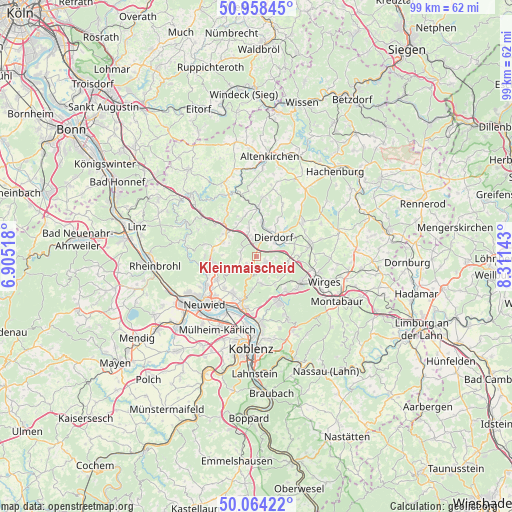
Kleinmaischeid GPS coordinates[2]
50° 30' 48.42" North, 7° 36' 29.88" East
| Map corner | latitude | longitude |
|---|---|---|
| Upper-left | 50.95845°, | 6.90518° |
| Center: | 50.51345°, | 7.6083° |
| Lower-right: | 50.06422°, | 8.31143° |
| Map W x H: | 99.4×99.4 km | = 61.8×61.8mi |
| max Lat: | 55.01917° ⇑52.5% North |
| Kleinmaischeid: | 50.51345° |
| min Lat: | ⇓47.5% South 47.40724° |
| min Long | Kleinmaischeid | max Long |
| 5.92978° | 7.6083° | 14.98853° |
| W 15.2%⇐ | ⇒84.8% E |
Elevation
Elevation of Kleinmaischeid is 302 m = 991 ft, and this is 52.9 m = 174 ft above average elevation for this country.
| Max E: |
1256 m = 4121 ft | 37.9% |
| Kleinmaischeid | 302 m 991 ft | |
| Avg. | 249.1 m = 817 ft | |
Min E: |
-5 m = -16 ft | 62.1% |
See also: Germany elevation on elevation.city.
Geographical zone
Kleinmaischeid is located in North temperate zone (between Tropic of Cancer and the Arctic Circle). Distance of this North polar circle is 1784.6 km =1108.9 mi to North.| Distance of | km | miles | from Kleinmaischeid |
|---|---|---|---|
| North Pole | 4390.5 | 2728.1 | to North |
| Arctic Circle | 1784.6 | 1108.9 | to North |
| Tropic Cancer | 3010.7 | 1870.8 | to South |
| Equator | 5616.6 | 3490 | to South |


Nearby cities:
15 places around Kleinmaischeid: (largest is in red/bold)
• Anhausen
4.4 km =2.7 mi,  250°
250°
• Caan
5.2 km =3.2 mi,  173°
173°
• Dernbach
4.1 km =2.5 mi,  351°
351°
• Dierdorf
4.8 km =3 mi,  40°
40°
• Großmaischeid
2.3 km =1.4 mi,  130°
130°
• Isenburg
3.4 km =2.1 mi,  189°
189°
• Kausen
4 km =2.5 mi,  118°
118°
• Meinborn
3.3 km =2.1 mi,  243°
243°
• Nauort
5.5 km =3.4 mi,  161°
161°
• Niederhofen
5.9 km =3.7 mi, 354°
• Rüscheid
3.7 km =2.3 mi,  306°
306°
• Sessenbach
4.8 km =3 mi,  147°
147°
• Stebach
3 km =1.9 mi,  83°
83°
• Thalhausen
2.3 km =1.4 mi,  229°
229°
• Urbach-Überdorf
5.1 km =3.2 mi,  342°
342°
Sources, notices
• [Note1] Compared only with cities in Germany existing in our database
• [Src1] Map data: © OpenStreetMap contributors (CC-BY-SA)
• [Src2] Other city data from geonames.org with taken over terms of usage.
• [Src3] Geographical zone / Annual Mean Temperature by Robert A. Rohde @ Wikipedia
