Großmaischeid geodata
Großmaischeid (Rheinland-Pfalz) is a seat of a fourth-order administrative division; located in Germany in Europe/Berlin (GMT+2) time zone. With population of 2,503 people, there are 4439 cities with bigger population in this country. Compared to other cities in Germany, 52.8% of cities are located further ↑North; 84.4% of cities are located further →East and 63.6% of cities have lower elevation than Großmaischeid. Note1
Administrative division(s):
- Level 1: Rheinland-Pfalz
- Level 3: Landkreis Neuwied
- Level 4: Großmaischeid


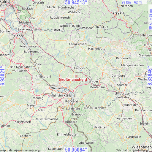
Großmaischeid GPS coordinates[2]
50° 30' 0" North, 7° 37' 59.988" East
| Map corner | latitude | longitude |
|---|---|---|
| Upper-left | 50.94513°, | 6.93021° |
| Center: | 50.5°, | 7.63333° |
| Lower-right: | 50.05064°, | 8.33646° |
| Map W x H: | 99.5×99.5 km | = 61.8×61.8mi |
| max Lat: | 55.01917° ⇑52.8% North |
| Großmaischeid: | 50.5° |
| min Lat: | ⇓47.2% South 47.40724° |
| min Long | Großmaischeid | max Long |
| 5.92978° | 7.63333° | 14.98853° |
| W 15.6%⇐ | ⇒84.4% E |
Elevation
Elevation of Großmaischeid is 312 m = 1024 ft, and this is 62.9 m = 206 ft above average elevation for this country.
| Max E: |
1256 m = 4121 ft | 36.4% |
| Großmaischeid | 312 m 1024 ft | |
| Avg. | 249.1 m = 817 ft | |
Min E: |
-5 m = -16 ft | 63.6% |
See also: Germany elevation on elevation.city.
Geographical zone
Großmaischeid is located in North temperate zone (between Tropic of Cancer and the Arctic Circle). Distance of this North polar circle is 1786.1 km =1109.8 mi to North.| Distance of | km | miles | from Großmaischeid |
|---|---|---|---|
| North Pole | 4392 | 2729.1 | to North |
| Arctic Circle | 1786.1 | 1109.8 | to North |
| Tropic Cancer | 3009.2 | 1869.8 | to South |
| Equator | 5615.1 | 3489.1 | to South |


Nearby cities:
15 places around Großmaischeid: (largest is in red/bold)
• Alsbach
4.5 km =2.8 mi,  153°
153°
• Breitenau
4.1 km =2.5 mi,  93°
93°
• Caan
3.9 km =2.4 mi,  197°
197°
• Deesen
4.9 km =3 mi,  75°
75°
• Isenburg
3 km =1.9 mi,  231°
231°
• Kammerforst
5.1 km =3.2 mi,  143°
143°
• Kausen
1.8 km =1.1 mi,  104°
104°
• Kleinmaischeid
2.3 km =1.4 mi,  310°
310°
• Meinborn
4.7 km =2.9 mi,  270°
270°
• Nauort
3.7 km =2.3 mi,  180°
180°
• Sessenbach
2.7 km =1.7 mi,  162°
162°
• Stebach
2.2 km =1.4 mi,  32°
32°
• Thalhausen
3.5 km =2.2 mi, 270°
• Wirscheid
4.4 km =2.7 mi, 147°
• Wittgert
4.7 km =2.9 mi, 90°
Sources, notices
• [Note1] Compared only with cities in Germany existing in our database
• [Src1] Map data: © OpenStreetMap contributors (CC-BY-SA)
• [Src2] Other city data from geonames.org with taken over terms of usage.
• [Src3] Geographical zone / Annual Mean Temperature by Robert A. Rohde @ Wikipedia
