Klanxbüll geodata
Klanxbüll (Schleswig-Holstein) is a seat of a fourth-order administrative division; located in Germany in Europe/Berlin (GMT+2) time zone. With population of 969 people, there are 7278 cities with bigger population in this country. Compared to other cities in Germany, 99.9% of cities are located further ↓South; 69.3% of cities are located further →East and 99.1% of cities have higher elevation than Klanxbüll. Note1
Administrative division(s):
- Level 1: Schleswig-Holstein
- Level 3: Kreis Nordfriesland
- Level 4: Klanxbüll


Klanxbüll GPS coordinates[2]
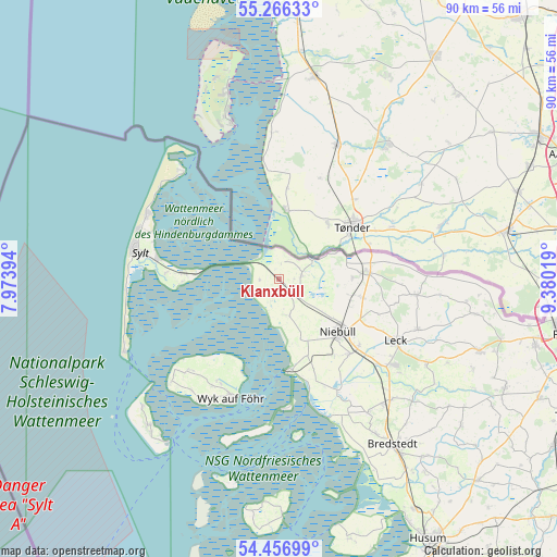
54° 51' 49.284" North, 8° 40' 37.416" East
| Map corner | latitude | longitude |
|---|---|---|
| Upper-left | 55.26633°, | 7.97394° |
| Center: | 54.86369°, | 8.67706° |
| Lower-right: | 54.45699°, | 9.38019° |
| Map W x H: | 90×90 km | = 55.9×55.9mi |
| max Lat: | 55.01917° ⇑0.1% North |
| Klanxbüll: | 54.86369° |
| min Lat: | ⇓99.9% South 47.40724° |
| min Long | Klanxbüll | max Long |
| 5.92978° | 8.67706° | 14.98853° |
| W 30.7%⇐ | ⇒69.3% E |
Elevation
Elevation of Klanxbüll is 0 m = 0 ft, and this is 249.1 m = 817 ft below average elevation for this country.
| Max E: |
1256 m = 4121 ft | 99.1% |
| Avg. | 249.1 m = 817 ft | |
| Klanxbüll | 0 m = 0 ft | |
Min E: |
-5 m = -16 ft | 0.9% |
See also: Germany elevation on elevation.city.
Geographical zone
Klanxbüll is located in North temperate zone (between Tropic of Cancer and the Arctic Circle). Distance of this North polar circle is 1300.9 km =808.3 mi to North.| Distance of | km | miles | from Klanxbüll |
|---|---|---|---|
| North Pole | 3906.8 | 2427.6 | to North |
| Arctic Circle | 1300.9 | 808.3 | to North |
| Tropic Cancer | 3494.4 | 2171.3 | to South |
| Equator | 6100.3 | 3790.5 | to South |


Nearby cities:
15 places around Klanxbüll: (largest is in red/bold)
• Aventoft
9.8 km =6.1 mi,  65°
65°
• Bosbüll
13.2 km =8.2 mi,  113°
113°
• Braderup
14 km =8.7 mi,  102°
102°
• Dagebüll
15 km =9.3 mi,  174°
174°
• Emmelsbüll-Horsbüll
5.4 km =3.4 mi,  164°
164°
• Friedrich-Wilhelm-Lübke-Koog
2.8 km =1.7 mi,  276°
276°
• Galmsbüll
13.5 km =8.4 mi, 159°
• Holm
12.6 km =7.8 mi, 105°
• Humptrup
12.1 km =7.5 mi,  88°
88°
• Klixbüll
15.5 km =9.6 mi,  115°
115°
• Neukirchen
3.6 km =2.2 mi,  84°
84°
• Niebüll
12.9 km =8 mi,  131°
131°
• Rodenäs
2.6 km =1.6 mi,  33°
33°
• Süderlügum
15 km =9.3 mi, 85°
• Uphusum
11.2 km =7 mi, 97°
Sources, notices
• [Note1] Compared only with cities in Germany existing in our database
• [Src1] Map data: © OpenStreetMap contributors (CC-BY-SA)
• [Src2] Other city data from geonames.org with taken over terms of usage.
• [Src3] Geographical zone / Annual Mean Temperature by Robert A. Rohde @ Wikipedia
