Aventoft geodata
Aventoft (Schleswig-Holstein) is a seat of a fourth-order administrative division; located in Germany in Europe/Berlin (GMT+2) time zone. With population of 523 people, there are 9235 cities with bigger population in this country. Compared to other cities in Germany, 100% of cities are located further ↓South; 67.7% of cities are located further →East and 97% of cities have higher elevation than Aventoft. Note1
Administrative division(s):
- Level 1: Schleswig-Holstein
- Level 3: Kreis Nordfriesland
- Level 4: Aventoft


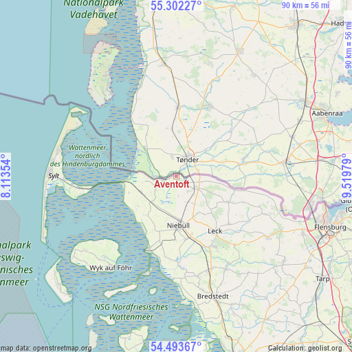
Aventoft GPS coordinates[2]
54° 54' 0" North, 8° 49' 0.012" East
| Map corner | latitude | longitude |
|---|---|---|
| Upper-left | 55.30227°, | 8.11354° |
| Center: | 54.9°, | 8.81667° |
| Lower-right: | 54.49367°, | 9.51979° |
| Map W x H: | 89.9×89.9 km | = 55.9×55.9mi |
| max Lat: | 55.01917° ⇑0% North |
| Aventoft: | 54.9° |
| min Lat: | ⇓100% South 47.40724° |
| min Long | Aventoft | max Long |
| 5.92978° | 8.81667° | 14.98853° |
| W 32.3%⇐ | ⇒67.7% E |
Elevation
Elevation of Aventoft is 4 m = 13 ft, and this is 245.1 m = 804 ft below average elevation for this country.
| Max E: |
1256 m = 4121 ft | 97% |
| Avg. | 249.1 m = 817 ft | |
| Aventoft | 4 m = 13 ft | |
Min E: |
-5 m = -16 ft | 3% |
See also: Germany elevation on elevation.city.
Geographical zone
Aventoft is located in North temperate zone (between Tropic of Cancer and the Arctic Circle). Distance of this North polar circle is 1296.9 km =805.9 mi to North.| Distance of | km | miles | from Aventoft |
|---|---|---|---|
| North Pole | 3902.8 | 2425.1 | to North |
| Arctic Circle | 1296.9 | 805.9 | to North |
| Tropic Cancer | 3498.4 | 2173.8 | to South |
| Equator | 6104.3 | 3793 | to South |


Nearby cities:
15 places around Aventoft: (largest is in red/bold)
• Bosbüll
9.8 km =6.1 mi,  160°
160°
• Braderup
8.6 km =5.3 mi,  146°
146°
• Ellhöft
8.7 km =5.4 mi,  102°
102°
• Emmelsbüll-Horsbüll
11.9 km =7.4 mi,  218°
218°
• Holm
8.1 km =5 mi, 156°
• Humptrup
4.9 km =3 mi,  139°
139°
• Klanxbüll
9.8 km =6.1 mi,  245°
245°
• Klixbüll
11.9 km =7.4 mi, 154°
• Lexgaard
10.5 km =6.5 mi,  134°
134°
• Neukirchen
6.5 km =4 mi,  235°
235°
• Rodenäs
7.7 km =4.8 mi,  256°
256°
• Süderlügum
6.7 km =4.2 mi,  115°
115°
• Tinningstedt
11.9 km =7.4 mi, 141°
• Uphusum
6 km =3.7 mi, 159°
• Westre
12 km =7.5 mi, 117°
Sources, notices
• [Note1] Compared only with cities in Germany existing in our database
• [Src1] Map data: © OpenStreetMap contributors (CC-BY-SA)
• [Src2] Other city data from geonames.org with taken over terms of usage.
• [Src3] Geographical zone / Annual Mean Temperature by Robert A. Rohde @ Wikipedia
