Kaltenborn geodata
Kaltenborn (Rheinland-Pfalz) is a seat of a fourth-order administrative division; located in Germany in Europe/Berlin (GMT+2) time zone. With population of 420 people, there are 9635 cities with bigger population in this country. Compared to other cities in Germany, 54.7% of cities are located further ↑North; 93.2% of cities are located further →East and 91.6% of cities have lower elevation than Kaltenborn. Note1
Administrative division(s):
- Level 1: Rheinland-Pfalz
- Level 3: Landkreis Ahrweiler
- Level 4: Kaltenborn


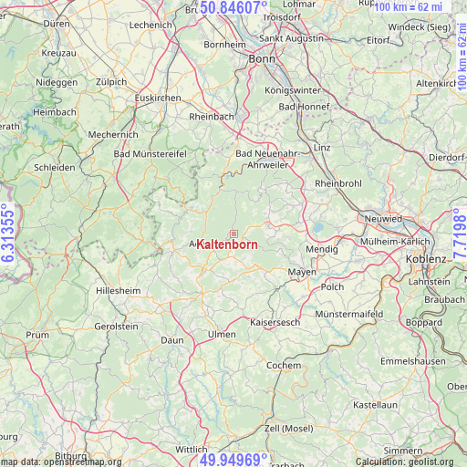
Kaltenborn GPS coordinates[2]
50° 24' 0" North, 7° 1' 0.012" East
| Map corner | latitude | longitude |
|---|---|---|
| Upper-left | 50.84607°, | 6.31355° |
| Center: | 50.4°, | 7.01667° |
| Lower-right: | 49.94969°, | 7.7198° |
| Map W x H: | 99.7×99.7 km | = 62×62mi |
| max Lat: | 55.01917° ⇑54.7% North |
| Kaltenborn: | 50.4° |
| min Lat: | ⇓45.3% South 47.40724° |
| min Long | Kaltenborn | max Long |
| 5.92978° | 7.01667° | 14.98853° |
| W 6.8%⇐ | ⇒93.2% E |
Elevation
Elevation of Kaltenborn is 537 m = 1762 ft, and this is 287.9 m = 945 ft above average elevation for this country.
| Max E: |
1256 m = 4121 ft | 8.4% |
| Kaltenborn | 537 m 1762 ft | |
| Avg. | 249.1 m = 817 ft | |
Min E: |
-5 m = -16 ft | 91.6% |
See also: Germany elevation on elevation.city.
Geographical zone
Kaltenborn is located in North temperate zone (between Tropic of Cancer and the Arctic Circle). Distance of this North polar circle is 1797.2 km =1116.7 mi to North.| Distance of | km | miles | from Kaltenborn |
|---|---|---|---|
| North Pole | 4403.1 | 2736 | to North |
| Arctic Circle | 1797.2 | 1116.7 | to North |
| Tropic Cancer | 2998 | 1862.9 | to South |
| Equator | 5604 | 3482.2 | to South |


Nearby cities:
15 places around Kaltenborn: (largest is in red/bold)
• Acht
5.1 km =3.2 mi,  136°
136°
• Adenau
6.3 km =3.9 mi,  251°
251°
• Arft
5.1 km =3.2 mi,  111°
111°
• Drees
5.7 km =3.5 mi,  192°
192°
• Dümpelfeld
6 km =3.7 mi,  308°
308°
• Hausten
7.1 km =4.4 mi,  90°
90°
• Herresbach
3.7 km =2.3 mi,  180°
180°
• Herschbroich
5.1 km =3.2 mi,  223°
223°
• Hohenleimbach
4 km =2.5 mi,  62°
62°
• Langenfeld
5.9 km =3.7 mi,  115°
115°
• Langscheid
7.3 km =4.5 mi,  104°
104°
• Leimbach
6.3 km =3.9 mi,  273°
273°
• Meuspath
6.6 km =4.1 mi,  212°
212°
• Siebenbach
2.2 km =1.4 mi,  147°
147°
• Welschenbach
5.1 km =3.2 mi, 136°
Sources, notices
• [Note1] Compared only with cities in Germany existing in our database
• [Src1] Map data: © OpenStreetMap contributors (CC-BY-SA)
• [Src2] Other city data from geonames.org with taken over terms of usage.
• [Src3] Geographical zone / Annual Mean Temperature by Robert A. Rohde @ Wikipedia
