Leimbach geodata
Leimbach (Rheinland-Pfalz) is a seat of a fourth-order administrative division; located in Germany in Europe/Berlin (GMT+2) time zone. In our database, there are 11009 cities with bigger population. Compared to other cities in Germany, 54.5% of cities are located further ↑North; 94.2% of cities are located further →East and 56.9% of cities have lower elevation than Leimbach. Note1


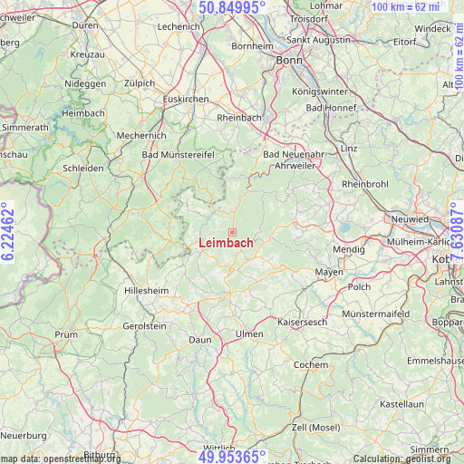
Leimbach GPS coordinates[2]
50° 24' 14.112" North, 6° 55' 39.864" East
| Map corner | latitude | longitude |
|---|---|---|
| Upper-left | 50.84995°, | 6.22462° |
| Center: | 50.40392°, | 6.92774° |
| Lower-right: | 49.95365°, | 7.63087° |
| Map W x H: | 99.7×99.7 km | = 62×62mi |
| max Lat: | 55.01917° ⇑54.5% North |
| Leimbach: | 50.40392° |
| min Lat: | ⇓45.5% South 47.40724° |
| min Long | Leimbach | max Long |
| 5.92978° | 6.92774° | 14.98853° |
| W 5.8%⇐ | ⇒94.2% E |
Elevation
Elevation of Leimbach is 271 m = 889 ft, and this is 21.9 m = 72 ft above average elevation for this country.
| Max E: |
1256 m = 4121 ft | 43.1% |
| Leimbach | 271 m 889 ft | |
| Avg. | 249.1 m = 817 ft | |
Min E: |
-5 m = -16 ft | 56.9% |
See also: Germany elevation on elevation.city.
Geographical zone
Leimbach is located in North temperate zone (between Tropic of Cancer and the Arctic Circle). Distance of this North polar circle is 1796.8 km =1116.5 mi to North.| Distance of | km | miles | from Leimbach |
|---|---|---|---|
| North Pole | 4402.7 | 2735.7 | to North |
| Arctic Circle | 1796.8 | 1116.5 | to North |
| Tropic Cancer | 2998.5 | 1863.2 | to South |
| Equator | 5604.4 | 3482.4 | to South |


Nearby cities:
15 places around Leimbach: (largest is in red/bold)
• Adenau
2.4 km =1.5 mi,  171°
171°
• Barweiler
6 km =3.7 mi,  226°
226°
• Dümpelfeld
3.6 km =2.2 mi,  25°
25°
• Fuchshofen
6.1 km =3.8 mi,  296°
296°
• Herschbroich
5 km =3.1 mi,  146°
146°
• Honerath
3 km =1.9 mi,  220°
220°
• Insul
3.4 km =2.1 mi,  346°
346°
• Kaltenborn
6.3 km =3.9 mi,  93°
93°
• Quiddelbach
6 km =3.7 mi,  176°
176°
• Reifferscheid
3 km =1.9 mi,  272°
272°
• Schuld
5.6 km =3.5 mi,  330°
330°
• Sierscheid
6 km =3.7 mi, 352°
• Wimbach
4.2 km =2.6 mi,  190°
190°
• Winnerath
4.6 km =2.9 mi,  307°
307°
• Wirft
6 km =3.7 mi, 226°
Sources, notices
• [Note1] Compared only with cities in Germany existing in our database
• [Src1] Map data: © OpenStreetMap contributors (CC-BY-SA)
• [Src2] Other city data from geonames.org with taken over terms of usage.
• [Src3] Geographical zone / Annual Mean Temperature by Robert A. Rohde @ Wikipedia
