Hohenwarthe geodata
Hohenwarthe (Saxony-Anhalt) is a populated place; located in Germany in Europe/Berlin (GMT+2) time zone. With population of 1,475 people, there are 5928 cities with bigger population in this country. Compared to other cities in Germany, 74.4% of cities are located further ↓South; 77.4% of cities are located further ←West and 77.9% of cities have higher elevation than Hohenwarthe. Note1


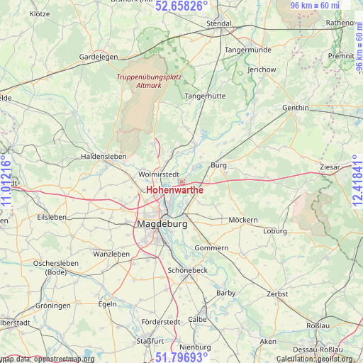
Hohenwarthe GPS coordinates[2]
52° 13' 46.848" North, 11° 42' 55.008" East
| Map corner | latitude | longitude |
|---|---|---|
| Upper-left | 52.65826°, | 11.01216° |
| Center: | 52.22968°, | 11.71528° |
| Lower-right: | 51.79693°, | 12.41841° |
| Map W x H: | 95.8×95.8 km | = 59.5×59.5mi |
| max Lat: | 55.01917° ⇑25.6% North |
| Hohenwarthe: | 52.22968° |
| min Lat: | ⇓74.4% South 47.40724° |
| min Long | Hohenwarthe | max Long |
| 5.92978° | 11.71528° | 14.98853° |
| W 77.4%⇐ | ⇒22.6% E |
Elevation
Elevation of Hohenwarthe is 53 m = 174 ft, and this is 196.1 m = 643 ft below average elevation for this country.
| Max E: |
1256 m = 4121 ft | 77.9% |
| Avg. | 249.1 m = 817 ft | |
| Hohenwarthe | 53 m = 174 ft | |
Min E: |
-5 m = -16 ft | 22.1% |
See also: Germany elevation on elevation.city.
Geographical zone
Hohenwarthe is located in North temperate zone (between Tropic of Cancer and the Arctic Circle). Distance of this North polar circle is 1593.8 km =990.3 mi to North.| Distance of | km | miles | from Hohenwarthe |
|---|---|---|---|
| North Pole | 4199.7 | 2609.6 | to North |
| Arctic Circle | 1593.8 | 990.3 | to North |
| Tropic Cancer | 3201.5 | 1989.3 | to South |
| Equator | 5807.4 | 3608.5 | to South |


Nearby cities:
15 places around Hohenwarthe: (largest is in red/bold)
• Barleben
7.3 km =4.5 mi,  245°
245°
• Biederitz
8.9 km =5.5 mi,  179°
179°
• Farsleben
6.8 km =4.2 mi,  321°
321°
• Gerwisch
6.1 km =3.8 mi,  164°
164°
• Glindenberg
2.4 km =1.5 mi,  294°
294°
• Jersleben
9.4 km =5.8 mi,  279°
279°
• Königsborn
10.5 km =6.5 mi,  165°
165°
• Körbelitz
7.1 km =4.4 mi,  139°
139°
• Loitsche
7.7 km =4.8 mi,  352°
352°
• Lostau
2.8 km =1.7 mi,  146°
146°
• Möser
5.6 km =3.5 mi,  108°
108°
• Rogätz
10.3 km =6.4 mi,  19°
19°
• Schermen
6.7 km =4.2 mi,  87°
87°
• Wolmirstedt
6.2 km =3.9 mi, 289°
• Zielitz
7.2 km =4.5 mi,  337°
337°
Sources, notices
• [Note1] Compared only with cities in Germany existing in our database
• [Src1] Map data: © OpenStreetMap contributors (CC-BY-SA)
• [Src2] Other city data from geonames.org with taken over terms of usage.
• [Src3] Geographical zone / Annual Mean Temperature by Robert A. Rohde @ Wikipedia
