Wolmirstedt geodata
Wolmirstedt (Saxony-Anhalt) is a populated place; located in Germany in Europe/Berlin (GMT+2) time zone. With population of 10,860 people, there are 1517 cities with bigger population in this country. Compared to other cities in Germany, 74.6% of cities are located further ↓South; 76.2% of cities are located further ←West and 78.3% of cities have higher elevation than Wolmirstedt. Note1


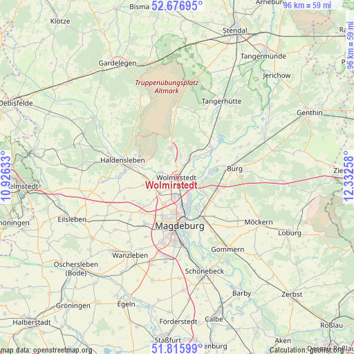
Wolmirstedt GPS coordinates[2]
52° 14' 54.816" North, 11° 37' 46.02" East
| Map corner | latitude | longitude |
|---|---|---|
| Upper-left | 52.67695°, | 10.92633° |
| Center: | 52.24856°, | 11.62945° |
| Lower-right: | 51.81599°, | 12.33258° |
| Map W x H: | 95.7×95.7 km | = 59.5×59.5mi |
| max Lat: | 55.01917° ⇑25.4% North |
| Wolmirstedt: | 52.24856° |
| min Lat: | ⇓74.6% South 47.40724° |
| min Long | Wolmirstedt | max Long |
| 5.92978° | 11.62945° | 14.98853° |
| W 76.2%⇐ | ⇒23.8% E |
Elevation
Elevation of Wolmirstedt is 52 m = 171 ft, and this is 197.1 m = 647 ft below average elevation for this country.
| Max E: |
1256 m = 4121 ft | 78.3% |
| Avg. | 249.1 m = 817 ft | |
| Wolmirstedt | 52 m = 171 ft | |
Min E: |
-5 m = -16 ft | 21.7% |
See also: Germany elevation on elevation.city.
Geographical zone
Wolmirstedt is located in North temperate zone (between Tropic of Cancer and the Arctic Circle). Distance of this North polar circle is 1591.7 km =989 mi to North.| Distance of | km | miles | from Wolmirstedt |
|---|---|---|---|
| North Pole | 4197.6 | 2608.3 | to North |
| Arctic Circle | 1591.7 | 989 | to North |
| Tropic Cancer | 3203.6 | 1990.6 | to South |
| Equator | 5809.5 | 3609.9 | to South |


Nearby cities:
15 places around Wolmirstedt: (largest is in red/bold)
• Barleben
5.2 km =3.2 mi,  188°
188°
• Colbitz
7.8 km =4.8 mi,  347°
347°
• Dahlenwarsleben
8.6 km =5.3 mi,  226°
226°
• Ebendorf
7.9 km =4.9 mi,  207°
207°
• Farsleben
3.6 km =2.2 mi,  26°
26°
• Glindenberg
3.9 km =2.4 mi,  106°
106°
• Groß Ammensleben
7.5 km =4.7 mi,  256°
256°
• Hohenwarthe
6.2 km =3.9 mi, 109°
• Jersleben
3.4 km =2.1 mi, 261°
• Klein Ammensleben
8.2 km =5.1 mi,  245°
245°
• Loitsche
7.3 km =4.5 mi,  40°
40°
• Lostau
8.6 km =5.3 mi,  120°
120°
• Meitzendorf
6.1 km =3.8 mi, 229°
• Samswegen
4.8 km =3 mi,  286°
286°
• Zielitz
5.5 km =3.4 mi, 34°
Sources, notices
• [Note1] Compared only with cities in Germany existing in our database
• [Src1] Map data: © OpenStreetMap contributors (CC-BY-SA)
• [Src2] Other city data from geonames.org with taken over terms of usage.
• [Src3] Geographical zone / Annual Mean Temperature by Robert A. Rohde @ Wikipedia
