Hahnenbach geodata
Hahnenbach (Rheinland-Pfalz) is a seat of a fourth-order administrative division; located in Germany in Europe/Berlin (GMT+2) time zone. With population of 653 people, there are 8539 cities with bigger population in this country. Compared to other cities in Germany, 68.7% of cities are located further ↑North; 88.3% of cities are located further →East and 53.1% of cities have lower elevation than Hahnenbach. Note1
Administrative division(s):
- Level 1: Rheinland-Pfalz
- Level 3: Landkreis Bad Kreuznach
- Level 4: Hahnenbach


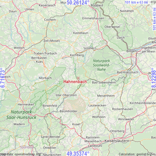
Hahnenbach GPS coordinates[2]
49° 48' 34.632" North, 7° 25' 11.46" East
| Map corner | latitude | longitude |
|---|---|---|
| Upper-left | 50.26124°, | 6.71673° |
| Center: | 49.80962°, | 7.41985° |
| Lower-right: | 49.35374°, | 8.12298° |
| Map W x H: | 100.9×100.9 km | = 62.7×62.7mi |
| max Lat: | 55.01917° ⇑68.7% North |
| Hahnenbach: | 49.80962° |
| min Lat: | ⇓31.3% South 47.40724° |
| min Long | Hahnenbach | max Long |
| 5.92978° | 7.41985° | 14.98853° |
| W 11.7%⇐ | ⇒88.3% E |
Elevation
Elevation of Hahnenbach is 247 m = 810 ft, and this is 2.1 m = 7 ft below average elevation for this country.
| Max E: |
1256 m = 4121 ft | 46.9% |
| Avg. | 249.1 m = 817 ft | |
| Hahnenbach | 247 m = 810 ft | |
Min E: |
-5 m = -16 ft | 53.1% |
See also: Germany elevation on elevation.city.
Geographical zone
Hahnenbach is located in North temperate zone (between Tropic of Cancer and the Arctic Circle). Distance of this North polar circle is 1862.9 km =1157.6 mi to North.| Distance of | km | miles | from Hahnenbach |
|---|---|---|---|
| North Pole | 4468.8 | 2776.8 | to North |
| Arctic Circle | 1862.9 | 1157.6 | to North |
| Tropic Cancer | 2932.4 | 1822.1 | to South |
| Equator | 5538.3 | 3441.3 | to South |


Nearby cities:
15 places around Hahnenbach: (largest is in red/bold)
• Bergen
2.9 km =1.8 mi,  184°
184°
• Bollenbach
5.7 km =3.5 mi,  297°
297°
• Brauweiler
5.8 km =3.6 mi,  82°
82°
• Breitenthal
6.3 km =3.9 mi,  260°
260°
• Bruschied
3 km =1.9 mi,  331°
331°
• Bundenbach
4.7 km =2.9 mi,  321°
321°
• Griebelschied
1.8 km =1.1 mi,  233°
233°
• Heinzenberg
4.6 km =2.9 mi, 80°
• Hennweiler
1.2 km =0.7 mi,  50°
50°
• Hochstetten-Dhaun
5.9 km =3.7 mi,  100°
100°
• Kirn
3.5 km =2.2 mi,  130°
130°
• Niederhosenbach
4 km =2.5 mi,  254°
254°
• Oberhosenbach
6.3 km =3.9 mi,  277°
277°
• Sonnschied
2.7 km =1.7 mi,  286°
286°
• Wickenrodt
5.1 km =3.2 mi, 278°
Sources, notices
• [Note1] Compared only with cities in Germany existing in our database
• [Src1] Map data: © OpenStreetMap contributors (CC-BY-SA)
• [Src2] Other city data from geonames.org with taken over terms of usage.
• [Src3] Geographical zone / Annual Mean Temperature by Robert A. Rohde @ Wikipedia
