Kirn geodata
Kirn (Rheinland-Pfalz) is a populated place; located in Germany in Europe/Berlin (GMT+2) time zone. With population of 8,762 people, there are 1830 cities with bigger population in this country. Compared to other cities in Germany, 69.2% of cities are located further ↑North; 87.8% of cities are located further →East and 53.4% of cities have higher elevation than Kirn. Note1


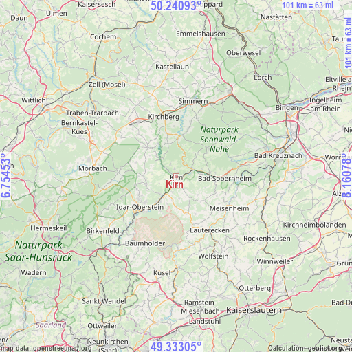
Kirn GPS coordinates[2]
49° 47' 20.832" North, 7° 27' 27.54" East
| Map corner | latitude | longitude |
|---|---|---|
| Upper-left | 50.24093°, | 6.75453° |
| Center: | 49.78912°, | 7.45765° |
| Lower-right: | 49.33305°, | 8.16078° |
| Map W x H: | 100.9×100.9 km | = 62.7×62.7mi |
| max Lat: | 55.01917° ⇑69.2% North |
| Kirn: | 49.78912° |
| min Lat: | ⇓30.8% South 47.40724° |
| min Long | Kirn | max Long |
| 5.92978° | 7.45765° | 14.98853° |
| W 12.2%⇐ | ⇒87.8% E |
Elevation
Elevation of Kirn is 201 m = 659 ft, and this is 48.1 m = 158 ft below average elevation for this country.
| Max E: |
1256 m = 4121 ft | 53.4% |
| Avg. | 249.1 m = 817 ft | |
| Kirn | 201 m = 659 ft | |
Min E: |
-5 m = -16 ft | 46.6% |
See also: Germany elevation on elevation.city.
Geographical zone
Kirn is located in North temperate zone (between Tropic of Cancer and the Arctic Circle). Distance of this North polar circle is 1865.1 km =1158.9 mi to North.| Distance of | km | miles | from Kirn |
|---|---|---|---|
| North Pole | 4471 | 2778.1 | to North |
| Arctic Circle | 1865.1 | 1158.9 | to North |
| Tropic Cancer | 2930.1 | 1820.7 | to South |
| Equator | 5536 | 3439.9 | to South |


Nearby cities:
15 places around Kirn: (largest is in red/bold)
• Bergen
3 km =1.9 mi,  257°
257°
• Brauweiler
4.3 km =2.7 mi,  44°
44°
• Bruschied
6.4 km =4 mi,  319°
319°
• Bärenbach
4.4 km =2.7 mi,  187°
187°
• Griebelschied
4.3 km =2.7 mi,  286°
286°
• Hahnenbach
3.5 km =2.2 mi,  310°
310°
• Heinzenberg
3.6 km =2.2 mi,  31°
31°
• Hennweiler
3.5 km =2.2 mi,  330°
330°
• Hochstetten-Dhaun
3.3 km =2.1 mi,  68°
68°
• Horbach
5.2 km =3.2 mi,  54°
54°
• Martinstein
6.4 km =4 mi,  75°
75°
• Meckenbach
3.1 km =1.9 mi,  101°
101°
• Schmidthachenbach
6.2 km =3.9 mi,  174°
174°
• Simmertal
5.2 km =3.2 mi,  63°
63°
• Sonnschied
6.2 km =3.9 mi,  299°
299°
Sources, notices
• [Note1] Compared only with cities in Germany existing in our database
• [Src1] Map data: © OpenStreetMap contributors (CC-BY-SA)
• [Src2] Other city data from geonames.org with taken over terms of usage.
• [Src3] Geographical zone / Annual Mean Temperature by Robert A. Rohde @ Wikipedia
