Grothusenkoog geodata
Grothusenkoog (Schleswig-Holstein) is a seat of a fourth-order administrative division; located in Germany in Europe/Berlin (GMT+2) time zone. With population of 29 people, there are 10999 cities with bigger population in this country. Compared to other cities in Germany, 96.3% of cities are located further ↓South; 68.4% of cities are located further →East and 98.6% of cities have higher elevation than Grothusenkoog. Note1
Administrative division(s):
- Level 1: Schleswig-Holstein
- Level 3: Kreis Nordfriesland
- Level 4: Grothusenkoog


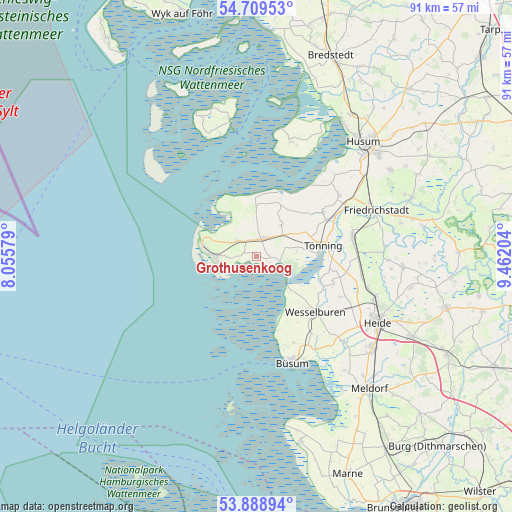
Grothusenkoog GPS coordinates[2]
54° 18' 4.608" North, 8° 45' 32.076" East
| Map corner | latitude | longitude |
|---|---|---|
| Upper-left | 54.70953°, | 8.05579° |
| Center: | 54.30128°, | 8.75891° |
| Lower-right: | 53.88894°, | 9.46204° |
| Map W x H: | 91.2×91.2 km | = 56.7×56.7mi |
| max Lat: | 55.01917° ⇑3.7% North |
| Grothusenkoog: | 54.30128° |
| min Lat: | ⇓96.3% South 47.40724° |
| min Long | Grothusenkoog | max Long |
| 5.92978° | 8.75891° | 14.98853° |
| W 31.6%⇐ | ⇒68.4% E |
Elevation
Elevation of Grothusenkoog is 1 m = 3 ft, and this is 248.1 m = 814 ft below average elevation for this country.
| Max E: |
1256 m = 4121 ft | 98.6% |
| Avg. | 249.1 m = 817 ft | |
| Grothusenkoog | 1 m = 3 ft | |
Min E: |
-5 m = -16 ft | 1.4% |
See also: Germany elevation on elevation.city.
Geographical zone
Grothusenkoog is located in North temperate zone (between Tropic of Cancer and the Arctic Circle). Distance of this North polar circle is 1363.4 km =847.2 mi to North.| Distance of | km | miles | from Grothusenkoog |
|---|---|---|---|
| North Pole | 3969.3 | 2466.4 | to North |
| Arctic Circle | 1363.4 | 847.2 | to North |
| Tropic Cancer | 3431.8 | 2132.4 | to South |
| Equator | 6037.7 | 3751.7 | to South |


Nearby cities:
15 places around Grothusenkoog: (largest is in red/bold)
• Garding
3.5 km =2.2 mi,  23°
23°
• Hillgroven
12.4 km =7.7 mi,  139°
139°
• Katharinenheerd
6 km =3.7 mi,  53°
53°
• Kotzenbüll
10.1 km =6.3 mi,  69°
69°
• Osterhever
9.4 km =5.8 mi,  2°
2°
• Poppenbüll
6.6 km =4.1 mi, 1°
• Sankt Peter-Ording
7.6 km =4.7 mi,  271°
271°
• Tating
4.3 km =2.7 mi,  309°
309°
• Tetenbüll
7.2 km =4.5 mi,  38°
38°
• Tönning
12.1 km =7.5 mi,  80°
80°
• Tümlauer Koog
7.3 km =4.5 mi,  317°
317°
• Vollerwiek
2.8 km =1.7 mi,  113°
113°
• Welt
2.3 km =1.4 mi,  86°
86°
• Wesselburenerkoog
9.9 km =6.2 mi,  125°
125°
• Westerhever
10.4 km =6.5 mi,  329°
329°
Sources, notices
• [Note1] Compared only with cities in Germany existing in our database
• [Src1] Map data: © OpenStreetMap contributors (CC-BY-SA)
• [Src2] Other city data from geonames.org with taken over terms of usage.
• [Src3] Geographical zone / Annual Mean Temperature by Robert A. Rohde @ Wikipedia
