Tönning geodata
Tönning (Schleswig-Holstein) is a populated place; located in Germany in Europe/Berlin (GMT+2) time zone. With population of 5,008 people, there are 2828 cities with bigger population in this country. Compared to other cities in Germany, 96.5% of cities are located further ↓South; 66.1% of cities are located further →East and 99.1% of cities have higher elevation than Tönning. Note1
Administrative division(s):
- Level 1: Schleswig-Holstein
- Level 3: Kreis Nordfriesland
- Level 4: Tönning


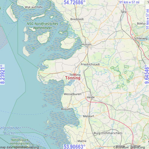
Tönning GPS coordinates[2]
54° 19' 7.644" North, 8° 56' 32.424" East
| Map corner | latitude | longitude |
|---|---|---|
| Upper-left | 54.72686°, | 8.23921° |
| Center: | 54.31879°, | 8.94234° |
| Lower-right: | 53.90663°, | 9.64546° |
| Map W x H: | 91.2×91.2 km | = 56.7×56.7mi |
| max Lat: | 55.01917° ⇑3.5% North |
| Tönning: | 54.31879° |
| min Lat: | ⇓96.5% South 47.40724° |
| min Long | Tönning | max Long |
| 5.92978° | 8.94234° | 14.98853° |
| W 33.9%⇐ | ⇒66.1% E |
Elevation
Elevation of Tönning is 0 m = 0 ft, and this is 249.1 m = 817 ft below average elevation for this country.
| Max E: |
1256 m = 4121 ft | 99.1% |
| Avg. | 249.1 m = 817 ft | |
| Tönning | 0 m = 0 ft | |
Min E: |
-5 m = -16 ft | 0.9% |
See also: Germany elevation on elevation.city.
Geographical zone
Tönning is located in North temperate zone (between Tropic of Cancer and the Arctic Circle). Distance of this North polar circle is 1361.5 km =846 mi to North.| Distance of | km | miles | from Tönning |
|---|---|---|---|
| North Pole | 3967.4 | 2465.2 | to North |
| Arctic Circle | 1361.5 | 846 | to North |
| Tropic Cancer | 3433.8 | 2133.7 | to South |
| Equator | 6039.7 | 3752.9 | to South |


Nearby cities:
15 places around Tönning: (largest is in red/bold)
• Groven
3.4 km =2.1 mi,  128°
128°
• Hemme
6.2 km =3.9 mi, 129°
• Karolinenkoog
4.2 km =2.6 mi,  158°
158°
• Katharinenheerd
7.3 km =4.5 mi,  282°
282°
• Kotzenbüll
2.9 km =1.8 mi,  303°
303°
• Krempel
5.9 km =3.7 mi,  92°
92°
• Lehe
5.8 km =3.6 mi,  64°
64°
• Lunden
5.6 km =3.5 mi,  75°
75°
• Oldenswort
6 km =3.7 mi,  358°
358°
• Rehm-Flehde-Bargen
6.2 km =3.9 mi, 129°
• Schülp
8.5 km =5.3 mi,  184°
184°
• Stelle-Wittenwurth
9.1 km =5.7 mi, 129°
• Strübbel
6 km =3.7 mi, 164°
• Tetenbüll
8.3 km =5.2 mi, 296°
• Wesselburenerkoog
8.6 km =5.3 mi,  206°
206°
Sources, notices
• [Note1] Compared only with cities in Germany existing in our database
• [Src1] Map data: © OpenStreetMap contributors (CC-BY-SA)
• [Src2] Other city data from geonames.org with taken over terms of usage.
• [Src3] Geographical zone / Annual Mean Temperature by Robert A. Rohde @ Wikipedia
