Großfahner geodata
Großfahner (Thuringia) is a seat of a fourth-order administrative division; located in Germany in Europe/Berlin (GMT+2) time zone. With population of 908 people, there are 7494 cities with bigger population in this country. Compared to other cities in Germany, 59.1% of cities are located further ↓South; 64.5% of cities are located further ←West and 53.4% of cities have higher elevation than Großfahner. Note1


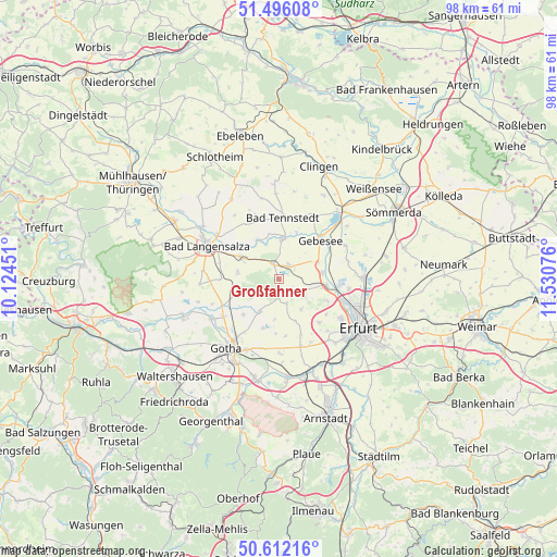
Großfahner GPS coordinates[2]
51° 3' 22.428" North, 10° 49' 39.468" East
| Map corner | latitude | longitude |
|---|---|---|
| Upper-left | 51.49608°, | 10.12451° |
| Center: | 51.05623°, | 10.82763° |
| Lower-right: | 50.61216°, | 11.53076° |
| Map W x H: | 98.3×98.3 km | = 61.1×61.1mi |
| max Lat: | 55.01917° ⇑40.9% North |
| Großfahner: | 51.05623° |
| min Lat: | ⇓59.1% South 47.40724° |
| min Long | Großfahner | max Long |
| 5.92978° | 10.82763° | 14.98853° |
| W 64.5%⇐ | ⇒35.5% E |
Elevation
Elevation of Großfahner is 201 m = 659 ft, and this is 48.1 m = 158 ft below average elevation for this country.
| Max E: |
1256 m = 4121 ft | 53.4% |
| Avg. | 249.1 m = 817 ft | |
| Großfahner | 201 m = 659 ft | |
Min E: |
-5 m = -16 ft | 46.6% |
See also: Germany elevation on elevation.city.
Geographical zone
Großfahner is located in North temperate zone (between Tropic of Cancer and the Arctic Circle). Distance of this North polar circle is 1724.3 km =1071.4 mi to North.| Distance of | km | miles | from Großfahner |
|---|---|---|---|
| North Pole | 4330.1 | 2690.6 | to North |
| Arctic Circle | 1724.3 | 1071.4 | to North |
| Tropic Cancer | 3071 | 1908.2 | to South |
| Equator | 5676.9 | 3527.5 | to South |


Nearby cities:
15 places around Großfahner: (largest is in red/bold)
• Andisleben
7.6 km =4.7 mi,  67°
67°
• Ballstädt
8.2 km =5.1 mi,  251°
251°
• Bienstädt
4.7 km =2.9 mi,  160°
160°
• Dachwig
3 km =1.9 mi,  38°
38°
• Döllstädt
3.1 km =1.9 mi,  345°
345°
• Elxleben
8.6 km =5.3 mi,  94°
94°
• Eschenbergen
5.8 km =3.6 mi,  235°
235°
• Gierstädt
1.5 km =0.9 mi,  183°
183°
• Großvargula
7.4 km =4.6 mi,  335°
335°
• Herbsleben
6.7 km =4.2 mi,  3°
3°
• Molschleben
7 km =4.3 mi,  206°
206°
• Tröchtelborn
6.3 km =3.9 mi,  186°
186°
• Walschleben
7.5 km =4.7 mi,  81°
81°
• Witterda
4.9 km =3 mi,  117°
117°
• Zimmernsupra
8.6 km =5.3 mi, 161°
Sources, notices
• [Note1] Compared only with cities in Germany existing in our database
• [Src1] Map data: © OpenStreetMap contributors (CC-BY-SA)
• [Src2] Other city data from geonames.org with taken over terms of usage.
• [Src3] Geographical zone / Annual Mean Temperature by Robert A. Rohde @ Wikipedia
