Grambow geodata
Grambow (Mecklenburg-Vorpommern) is a populated place; located in Germany in Europe/Berlin (GMT+2) time zone. With population of 957 people, there are 7318 cities with bigger population in this country. Compared to other cities in Germany, 84.6% of cities are located further ↓South; 99% of cities are located further ←West and 83.7% of cities have higher elevation than Grambow. Note1
Administrative division(s):
- Level 1: Mecklenburg-Vorpommern
- Level 3: Vorpommern-Greifswald
- Level 4: Grambow


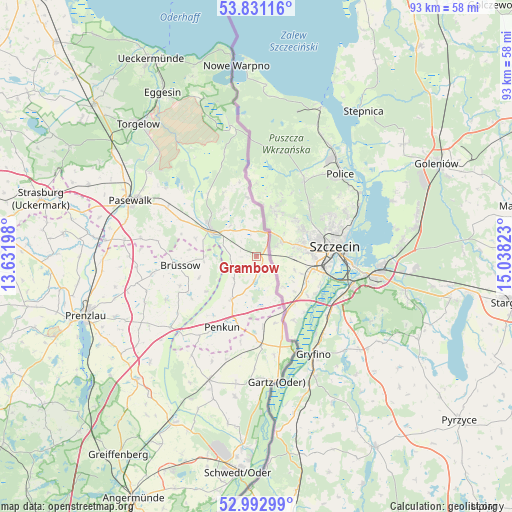
Grambow GPS coordinates[2]
53° 24' 50.904" North, 14° 20' 6.36" East
| Map corner | latitude | longitude |
|---|---|---|
| Upper-left | 53.83116°, | 13.63198° |
| Center: | 53.41414°, | 14.3351° |
| Lower-right: | 52.99299°, | 15.03823° |
| Map W x H: | 93.2×93.2 km | = 57.9×57.9mi |
| max Lat: | 55.01917° ⇑15.4% North |
| Grambow: | 53.41414° |
| min Lat: | ⇓84.6% South 47.40724° |
| min Long | Grambow | max Long |
| 5.92978° | 14.3351° | 14.98853° |
| W 99%⇐ | ⇒1% E |
Elevation
Elevation of Grambow is 38 m = 125 ft, and this is 211.1 m = 693 ft below average elevation for this country.
| Max E: |
1256 m = 4121 ft | 83.7% |
| Avg. | 249.1 m = 817 ft | |
| Grambow | 38 m = 125 ft | |
Min E: |
-5 m = -16 ft | 16.3% |
See also: Germany elevation on elevation.city.
Geographical zone
Grambow is located in North temperate zone (between Tropic of Cancer and the Arctic Circle). Distance of this North polar circle is 1462.1 km =908.5 mi to North.| Distance of | km | miles | from Grambow |
|---|---|---|---|
| North Pole | 4068 | 2527.7 | to North |
| Arctic Circle | 1462.1 | 908.5 | to North |
| Tropic Cancer | 3333.2 | 2071.2 | to South |
| Equator | 5939.1 | 3690.4 | to South |


Nearby cities:
15 places around Grambow: (largest is in red/bold)
• Boock
10.4 km =6.5 mi,  325°
325°
• Brüssow
14 km =8.7 mi,  263°
263°
• Casekow
24.1 km =15 mi,  200°
200°
• Gartz
23.2 km =14.4 mi,  170°
170°
• Grünow
27.8 km =17.3 mi,  247°
247°
• Krackow
9.1 km =5.7 mi,  210°
210°
• Mescherin
19.6 km =12.2 mi,  161°
161°
• Pasewalk
25 km =15.5 mi,  294°
294°
• Penkun
14.6 km =9.1 mi, 206°
• Rollwitz
24.6 km =15.3 mi, 285°
• Schenkenberg
26.1 km =16.2 mi, 258°
• Schönfeld
23.2 km =14.4 mi,  269°
269°
• Tantow
15.9 km =9.9 mi,  176°
176°
• Viereck
24.6 km =15.3 mi,  307°
307°
• Zerrenthin
18.5 km =11.5 mi,  298°
298°
Sources, notices
• [Note1] Compared only with cities in Germany existing in our database
• [Src1] Map data: © OpenStreetMap contributors (CC-BY-SA)
• [Src2] Other city data from geonames.org with taken over terms of usage.
• [Src3] Geographical zone / Annual Mean Temperature by Robert A. Rohde @ Wikipedia
