Gartz geodata
Gartz (Brandenburg) is a populated place; located in Germany in Europe/Berlin (GMT+2) time zone. With population of 2,638 people, there are 4297 cities with bigger population in this country. Compared to other cities in Germany, 82.9% of cities are located further ↓South; 99.1% of cities are located further ←West and 93.9% of cities have higher elevation than Gartz. Note1


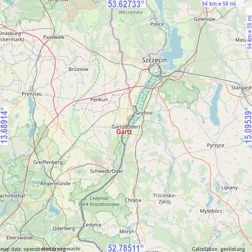
Gartz GPS coordinates[2]
53° 12' 29.844" North, 14° 23' 32.136" East
| Map corner | latitude | longitude |
|---|---|---|
| Upper-left | 53.62733°, | 13.68914° |
| Center: | 53.20829°, | 14.39226° |
| Lower-right: | 52.78511°, | 15.09539° |
| Map W x H: | 93.6×93.6 km | = 58.2×58.2mi |
| max Lat: | 55.01917° ⇑17.1% North |
| Gartz: | 53.20829° |
| min Lat: | ⇓82.9% South 47.40724° |
| min Long | Gartz | max Long |
| 5.92978° | 14.39226° | 14.98853° |
| W 99.1%⇐ | ⇒0.90000000000001% E |
Elevation
Elevation of Gartz is 11 m = 36 ft, and this is 238.1 m = 781 ft below average elevation for this country.
| Max E: |
1256 m = 4121 ft | 93.9% |
| Avg. | 249.1 m = 817 ft | |
| Gartz | 11 m = 36 ft | |
Min E: |
-5 m = -16 ft | 6.1% |
See also: Germany elevation on elevation.city.
Geographical zone
Gartz is located in North temperate zone (between Tropic of Cancer and the Arctic Circle). Distance of this North polar circle is 1485 km =922.7 mi to North.| Distance of | km | miles | from Gartz |
|---|---|---|---|
| North Pole | 4090.9 | 2542 | to North |
| Arctic Circle | 1485 | 922.7 | to North |
| Tropic Cancer | 3310.3 | 2056.9 | to South |
| Equator | 5916.2 | 3676.2 | to South |


Nearby cities:
15 places around Gartz: (largest is in red/bold)
• Brüssow
27.7 km =17.2 mi,  320°
320°
• Casekow
12.3 km =7.6 mi,  271°
271°
• Grambow
23.2 km =14.4 mi,  350°
350°
• Gramzow
25.6 km =15.9 mi, 271°
• Grünow
31.8 km =19.8 mi,  292°
292°
• Krackow
17.3 km =10.7 mi,  330°
330°
• Mescherin
5 km =3.1 mi,  30°
30°
• Meyenburg
20.9 km =13 mi,  209°
209°
• Passow
19.9 km =12.4 mi,  248°
248°
• Penkun
14.3 km =8.9 mi,  313°
313°
• Pinnow
26.1 km =16.2 mi,  231°
231°
• Schwedt (Oder)
18.1 km =11.2 mi,  204°
204°
• Schöneberg
27.8 km =17.3 mi,  216°
216°
• Tantow
7.6 km =4.7 mi,  338°
338°
• Zichow
23.7 km =14.7 mi,  264°
264°
Sources, notices
• [Note1] Compared only with cities in Germany existing in our database
• [Src1] Map data: © OpenStreetMap contributors (CC-BY-SA)
• [Src2] Other city data from geonames.org with taken over terms of usage.
• [Src3] Geographical zone / Annual Mean Temperature by Robert A. Rohde @ Wikipedia
