Grabau geodata
Grabau (Schleswig-Holstein) is a seat of a fourth-order administrative division; located in Germany in Europe/Berlin (GMT+2) time zone. With population of 820 people, there are 7825 cities with bigger population in this country. Compared to other cities in Germany, 90% of cities are located further ↓South; 54.9% of cities are located further ←West and 86.3% of cities have higher elevation than Grabau. Note1


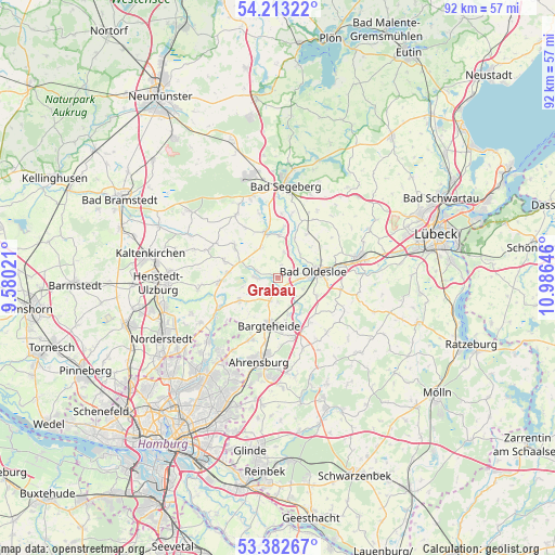
Grabau GPS coordinates[2]
53° 48' 0" North, 10° 16' 59.988" East
| Map corner | latitude | longitude |
|---|---|---|
| Upper-left | 54.21322°, | 9.58021° |
| Center: | 53.8°, | 10.28333° |
| Lower-right: | 53.38267°, | 10.98646° |
| Map W x H: | 92.3×92.3 km | = 57.4×57.4mi |
| max Lat: | 55.01917° ⇑10% North |
| Grabau: | 53.8° |
| min Lat: | ⇓90% South 47.40724° |
| min Long | Grabau | max Long |
| 5.92978° | 10.28333° | 14.98853° |
| W 54.9%⇐ | ⇒45.1% E |
Elevation
Elevation of Grabau is 32 m = 105 ft, and this is 217.1 m = 712 ft below average elevation for this country.
| Max E: |
1256 m = 4121 ft | 86.3% |
| Avg. | 249.1 m = 817 ft | |
| Grabau | 32 m = 105 ft | |
Min E: |
-5 m = -16 ft | 13.7% |
See also: Germany elevation on elevation.city.
Geographical zone
Grabau is located in North temperate zone (between Tropic of Cancer and the Arctic Circle). Distance of this North polar circle is 1419.2 km =881.8 mi to North.| Distance of | km | miles | from Grabau |
|---|---|---|---|
| North Pole | 4025.1 | 2501.1 | to North |
| Arctic Circle | 1419.2 | 881.8 | to North |
| Tropic Cancer | 3376.1 | 2097.8 | to South |
| Equator | 5982 | 3717 | to South |


Nearby cities:
15 places around Grabau: (largest is in red/bold)
• Bad Oldesloe
6.1 km =3.8 mi,  77°
77°
• Bargfeld-Stegen
7.2 km =4.5 mi,  240°
240°
• Bargteheide
8 km =5 mi,  187°
187°
• Elmenhorst
3.9 km =2.4 mi,  196°
196°
• Groß Niendorf
5.8 km =3.6 mi,  332°
332°
• Itzstedt
8.3 km =5.2 mi,  276°
276°
• Jersbek
8.6 km =5.3 mi,  210°
210°
• Leezen
7.7 km =4.8 mi,  343°
343°
• Neritz
1.9 km =1.2 mi,  180°
180°
• Neversdorf
7.4 km =4.6 mi,  0°
0°
• Nienwohld
6 km =3.7 mi,  256°
256°
• Pölitz
7.2 km =4.5 mi,  114°
114°
• Rümpel
4.8 km =3 mi, 112°
• Sülfeld
3.3 km =2.1 mi,  270°
270°
• Tremsbüttel
6.5 km =4 mi,  164°
164°
Sources, notices
• [Note1] Compared only with cities in Germany existing in our database
• [Src1] Map data: © OpenStreetMap contributors (CC-BY-SA)
• [Src2] Other city data from geonames.org with taken over terms of usage.
• [Src3] Geographical zone / Annual Mean Temperature by Robert A. Rohde @ Wikipedia
