Nienwohld geodata
Nienwohld (Schleswig-Holstein) is a seat of a fourth-order administrative division; located in Germany in Europe/Berlin (GMT+2) time zone. With population of 459 people, there are 9510 cities with bigger population in this country. Compared to other cities in Germany, 89.9% of cities are located further ↓South; 53.3% of cities are located further ←West and 84.5% of cities have higher elevation than Nienwohld. Note1


Nienwohld GPS coordinates[2]
53° 47' 12.984" North, 10° 11' 39.984" East
| Map corner | latitude | longitude |
|---|---|---|
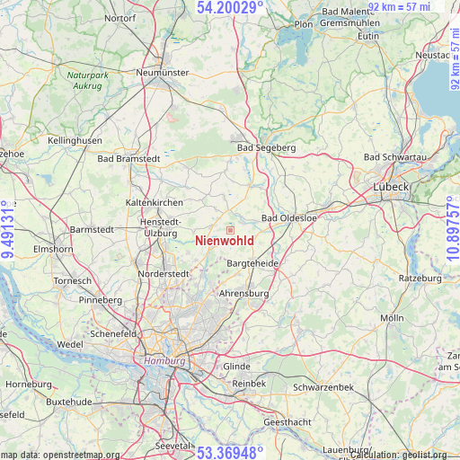
| Upper-left | 54.20029°, | 9.49131° |
| Center: | 53.78694°, | 10.19444° |
| Lower-right: | 53.36948°, | 10.89757° |
| Map W x H: | 92.4×92.4 km | = 57.4×57.4mi |
| max Lat: | 55.01917° ⇑10.1% North |
| Nienwohld: | 53.78694° |
| min Lat: | ⇓89.9% South 47.40724° |
| min Long | Nienwohld | max Long |
| 5.92978° | 10.19444° | 14.98853° |
| W 53.3%⇐ | ⇒46.7% E |
Elevation
Elevation of Nienwohld is 36 m = 118 ft, and this is 213.1 m = 699 ft below average elevation for this country.
| Max E: |
1256 m = 4121 ft | 84.5% |
| Avg. | 249.1 m = 817 ft | |
| Nienwohld | 36 m = 118 ft | |
Min E: |
-5 m = -16 ft | 15.5% |
See also: Germany elevation on elevation.city.
Geographical zone
Nienwohld is located in North temperate zone (between Tropic of Cancer and the Arctic Circle). Distance of this North polar circle is 1420.6 km =882.7 mi to North.| Distance of | km | miles | from Nienwohld |
|---|---|---|---|
| North Pole | 4026.5 | 2502 | to North |
| Arctic Circle | 1420.6 | 882.7 | to North |
| Tropic Cancer | 3374.6 | 2096.9 | to South |
| Equator | 5980.5 | 3716.1 | to South |


Nearby cities:
15 places around Nienwohld: (largest is in red/bold)
• Bargfeld-Stegen
2.2 km =1.4 mi,  192°
192°
• Bargteheide
8.1 km =5 mi,  143°
143°
• Elmenhorst
5.3 km =3.3 mi,  115°
115°
• Grabau
6 km =3.7 mi,  76°
76°
• Groß Niendorf
7.3 km =4.5 mi,  25°
25°
• Itzstedt
3.3 km =2.1 mi,  314°
314°
• Jersbek
6.1 km =3.8 mi,  166°
166°
• Kayhude
5.3 km =3.3 mi,  230°
230°
• Nahe
4.3 km =2.7 mi,  289°
289°
• Neritz
5.9 km =3.7 mi,  93°
93°
• Seth
6.8 km =4.2 mi,  348°
348°
• Sievershütten
8.2 km =5.1 mi,  318°
318°
• Stuvenborn
8.1 km =5 mi,  330°
330°
• Sülfeld
2.9 km =1.8 mi,  60°
60°
• Tremsbüttel
9 km =5.6 mi, 122°
Sources, notices
• [Note1] Compared only with cities in Germany existing in our database
• [Src1] Map data: © OpenStreetMap contributors (CC-BY-SA)
• [Src2] Other city data from geonames.org with taken over terms of usage.
• [Src3] Geographical zone / Annual Mean Temperature by Robert A. Rohde @ Wikipedia
