Gädheim geodata
Gädheim (Bavaria) is a seat of a fourth-order administrative division; located in Germany in Europe/Berlin (GMT+2) time zone. In our database, there are 11009 cities with bigger population. Compared to other cities in Germany, 63% of cities are located further ↑North; 56.3% of cities are located further ←West and 64.2% of cities have lower elevation than Gädheim. Note1
Administrative division(s):
- Level 1: Bavaria
- Level 2: Regierungsbezirk Unterfranken
- Level 3: Landkreis Haßberge
- Level 4: Gädheim


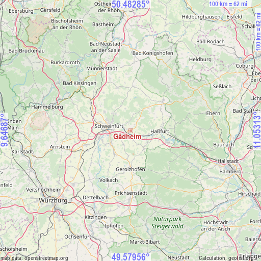
Gädheim GPS coordinates[2]
50° 1' 59.988" North, 10° 21' 0" East
| Map corner | latitude | longitude |
|---|---|---|
| Upper-left | 50.48285°, | 9.64687° |
| Center: | 50.03333°, | 10.35° |
| Lower-right: | 49.57956°, | 11.05313° |
| Map W x H: | 100.4×100.4 km | = 62.4×62.4mi |
| max Lat: | 55.01917° ⇑63% North |
| Gädheim: | 50.03333° |
| min Lat: | ⇓37% South 47.40724° |
| min Long | Gädheim | max Long |
| 5.92978° | 10.35° | 14.98853° |
| W 56.3%⇐ | ⇒43.7% E |
Elevation
Elevation of Gädheim is 316 m = 1037 ft, and this is 66.9 m = 219 ft above average elevation for this country.
| Max E: |
1256 m = 4121 ft | 35.8% |
| Gädheim | 316 m 1037 ft | |
| Avg. | 249.1 m = 817 ft | |
Min E: |
-5 m = -16 ft | 64.2% |
See also: Germany elevation on elevation.city.
Geographical zone
Gädheim is located in North temperate zone (between Tropic of Cancer and the Arctic Circle). Distance of this North polar circle is 1838 km =1142.1 mi to North.| Distance of | km | miles | from Gädheim |
|---|---|---|---|
| North Pole | 4443.9 | 2761.3 | to North |
| Arctic Circle | 1838 | 1142.1 | to North |
| Tropic Cancer | 2957.3 | 1837.6 | to South |
| Equator | 5563.2 | 3456.8 | to South |


Nearby cities:
15 places around Gädheim: (largest is in red/bold)
• Dittelbrunn
10.3 km =6.4 mi,  294°
294°
• Donnersdorf
8.8 km =5.5 mi,  147°
147°
• Gochsheim
5.1 km =3.2 mi,  248°
248°
• Grafenrheinfeld
11.3 km =7 mi, 250°
• Grettstadt
6 km =3.7 mi,  203°
203°
• Hausen
5 km =3.1 mi,  326°
326°
• Haßfurt
11.8 km =7.3 mi,  88°
88°
• Röthlein
11 km =6.8 mi,  239°
239°
• Schonungen
3.5 km =2.2 mi,  301°
301°
• Schwebheim
8.7 km =5.4 mi, 236°
• Schweinfurt
9.3 km =5.8 mi,  281°
281°
• Sennfeld
6.5 km =4 mi, 275°
• Sulzheim
9.3 km =5.8 mi,  187°
187°
• Wonfurt
8.5 km =5.3 mi,  102°
102°
• Üchtelhausen
8.7 km =5.4 mi,  318°
318°
Sources, notices
• [Note1] Compared only with cities in Germany existing in our database
• [Src1] Map data: © OpenStreetMap contributors (CC-BY-SA)
• [Src2] Other city data from geonames.org with taken over terms of usage.
• [Src3] Geographical zone / Annual Mean Temperature by Robert A. Rohde @ Wikipedia
