Friedrichsgabekoog geodata
Friedrichsgabekoog (Schleswig-Holstein) is a seat of a fourth-order administrative division; located in Germany in Europe/Berlin (GMT+2) time zone. With population of 70 people, there are 10915 cities with bigger population in this country. Compared to other cities in Germany, 94.4% of cities are located further ↓South; 66.1% of cities are located further →East and 99.1% of cities have higher elevation than Friedrichsgabekoog. Note1
Administrative division(s):
- Level 1: Schleswig-Holstein
- Level 3: Kreis Dithmarschen
- Level 4: Friedrichsgabekoog


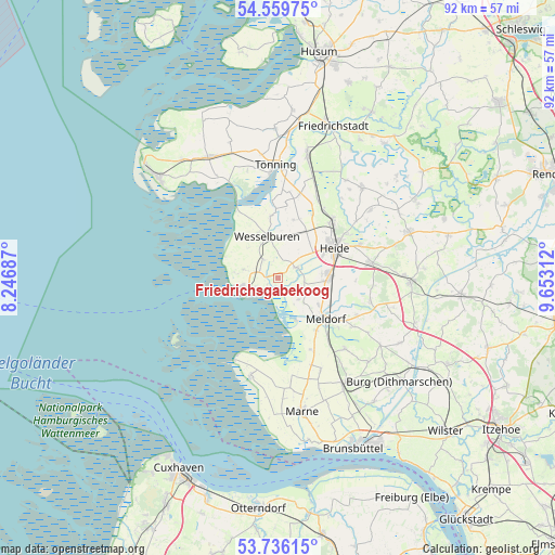
Friedrichsgabekoog GPS coordinates[2]
54° 9' 0" North, 8° 57' 0" East
| Map corner | latitude | longitude |
|---|---|---|
| Upper-left | 54.55975°, | 8.24687° |
| Center: | 54.15°, | 8.95° |
| Lower-right: | 53.73615°, | 9.65312° |
| Map W x H: | 91.6×91.6 km | = 56.9×56.9mi |
| max Lat: | 55.01917° ⇑5.6% North |
| Friedrichsgabekoog: | 54.15° |
| min Lat: | ⇓94.4% South 47.40724° |
| min Long | Friedrichsgabek | max Long |
| 5.92978° | 8.95° | 14.98853° |
| W 33.9%⇐ | ⇒66.1% E |
Elevation
Elevation of Friedrichsgabekoog is 0 m = 0 ft, and this is 249.1 m = 817 ft below average elevation for this country.
| Max E: |
1256 m = 4121 ft | 99.1% |
| Avg. | 249.1 m = 817 ft | |
| Friedrichsgabekoog | 0 m = 0 ft | |
Min E: |
-5 m = -16 ft | 0.9% |
See also: Germany elevation on elevation.city.
Geographical zone
Friedrichsgabekoog is located in North temperate zone (between Tropic of Cancer and the Arctic Circle). Distance of this North polar circle is 1380.3 km =857.7 mi to North.| Distance of | km | miles | from Friedrichsgabekoog |
|---|---|---|---|
| North Pole | 3986.1 | 2476.8 | to North |
| Arctic Circle | 1380.3 | 857.7 | to North |
| Tropic Cancer | 3415 | 2122 | to South |
| Equator | 6020.9 | 3741.2 | to South |


Nearby cities:
15 places around Friedrichsgabekoog: (largest is in red/bold)
• Büsum
6.3 km =3.9 mi,  253°
253°
• Büsumer Deichhausen
4.7 km =2.9 mi, 246°
• Epenwöhrden
8 km =5 mi,  123°
123°
• Hedwigenkoog
7.5 km =4.7 mi,  299°
299°
• Hemmingstedt
7.6 km =4.7 mi,  90°
90°
• Lieth
7.2 km =4.5 mi,  84°
84°
• Norderwöhrden
7.1 km =4.4 mi,  37°
37°
• Oesterdeichstrich
4.3 km =2.7 mi,  270°
270°
• Oesterwurth
7.7 km =4.8 mi,  16°
16°
• Reinsbüttel
4.1 km =2.5 mi,  322°
322°
• Süderdeich
6 km =3.7 mi,  338°
338°
• Wesselburen
7.1 km =4.4 mi,  346°
346°
• Wesselburener Deichhausen
2.1 km =1.3 mi,  329°
329°
• Westerdeichstrich
5.7 km =3.5 mi,  282°
282°
• Wöhrden
3.7 km =2.3 mi,  60°
60°
Sources, notices
• [Note1] Compared only with cities in Germany existing in our database
• [Src1] Map data: © OpenStreetMap contributors (CC-BY-SA)
• [Src2] Other city data from geonames.org with taken over terms of usage.
• [Src3] Geographical zone / Annual Mean Temperature by Robert A. Rohde @ Wikipedia
