Felde geodata
Felde (Schleswig-Holstein) is a seat of a fourth-order administrative division; located in Germany in Europe/Berlin (GMT+2) time zone. With population of 2,159 people, there are 4856 cities with bigger population in this country. Compared to other cities in Germany, 96.2% of cities are located further ↓South; 51% of cities are located further →East and 92% of cities have higher elevation than Felde. Note1
Administrative division(s):
- Level 1: Schleswig-Holstein
- Level 3: Kreis Rendsburg-Eckernförde
- Level 4: Felde


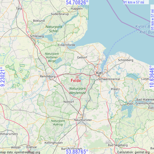
Felde GPS coordinates[2]
54° 18' 0" North, 9° 55' 59.988" East
| Map corner | latitude | longitude |
|---|---|---|
| Upper-left | 54.70826°, | 9.23021° |
| Center: | 54.3°, | 9.93333° |
| Lower-right: | 53.88765°, | 10.63646° |
| Map W x H: | 91.2×91.2 km | = 56.7×56.7mi |
| max Lat: | 55.01917° ⇑3.8% North |
| Felde: | 54.3° |
| min Lat: | ⇓96.2% South 47.40724° |
| min Long | Felde | max Long |
| 5.92978° | 9.93333° | 14.98853° |
| W 49%⇐ | ⇒51% E |
Elevation
Elevation of Felde is 16 m = 52 ft, and this is 233.1 m = 765 ft below average elevation for this country.
| Max E: |
1256 m = 4121 ft | 92% |
| Avg. | 249.1 m = 817 ft | |
| Felde | 16 m = 52 ft | |
Min E: |
-5 m = -16 ft | 8% |
See also: Germany elevation on elevation.city.
Geographical zone
Felde is located in North temperate zone (between Tropic of Cancer and the Arctic Circle). Distance of this North polar circle is 1363.6 km =847.3 mi to North.| Distance of | km | miles | from Felde |
|---|---|---|---|
| North Pole | 3969.5 | 2466.5 | to North |
| Arctic Circle | 1363.6 | 847.3 | to North |
| Tropic Cancer | 3431.7 | 2132.4 | to South |
| Equator | 6037.6 | 3751.6 | to South |


Nearby cities:
15 places around Felde: (largest is in red/bold)
• Achterwehr
2.6 km =1.6 mi,  55°
55°
• Blumenthal
8.6 km =5.3 mi,  149°
149°
• Bovenau
7.5 km =4.7 mi,  299°
299°
• Bredenbek
4.6 km =2.9 mi, 302°
• Emkendorf
6.6 km =4.1 mi,  235°
235°
• Groß Vollstedt
8.6 km =5.3 mi,  210°
210°
• Haßmoor
7.6 km =4.7 mi,  270°
270°
• Krummwisch
4.3 km =2.7 mi,  329°
329°
• Melsdorf
6.7 km =4.2 mi,  74°
74°
• Mielkendorf
7.8 km =4.8 mi,  103°
103°
• Quarnbek
4.9 km =3 mi,  41°
41°
• Rodenbek
5.7 km =3.5 mi,  108°
108°
• Rumohr
7.7 km =4.8 mi,  129°
129°
• Schierensee
6.4 km =4 mi, 149°
• Westensee
3.7 km =2.3 mi,  220°
220°
Sources, notices
• [Note1] Compared only with cities in Germany existing in our database
• [Src1] Map data: © OpenStreetMap contributors (CC-BY-SA)
• [Src2] Other city data from geonames.org with taken over terms of usage.
• [Src3] Geographical zone / Annual Mean Temperature by Robert A. Rohde @ Wikipedia
