Eitorf geodata
Eitorf (North Rhine-Westphalia) is a seat of a fourth-order administrative division; located in Germany in Europe/Berlin (GMT+2) time zone. With population of 19,761 people, there are 787 cities with bigger population in this country. Compared to other cities in Germany, 53.5% of cities are located further ↓South; 88% of cities are located further →East and 68% of cities have higher elevation than Eitorf. Note1
Administrative division(s):
- Level 1: North Rhine-Westphalia
- Level 2: Regierungsbezirk Köln
- Level 3: Rhein-Sieg-Kreis
- Level 4: Eitorf


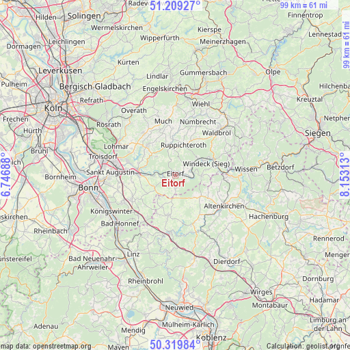
Eitorf GPS coordinates[2]
50° 46' 0.012" North, 7° 27' 0" East
| Map corner | latitude | longitude |
|---|---|---|
| Upper-left | 51.20927°, | 6.74688° |
| Center: | 50.76667°, | 7.45° |
| Lower-right: | 50.31984°, | 8.15313° |
| Map W x H: | 98.9×98.9 km | = 61.5×61.5mi |
| max Lat: | 55.01917° ⇑46.5% North |
| Eitorf: | 50.76667° |
| min Lat: | ⇓53.5% South 47.40724° |
| min Long | Eitorf | max Long |
| 5.92978° | 7.45° | 14.98853° |
| W 12%⇐ | ⇒88% E |
Elevation
Elevation of Eitorf is 102 m = 335 ft, and this is 147.1 m = 483 ft below average elevation for this country.
| Max E: |
1256 m = 4121 ft | 68% |
| Avg. | 249.1 m = 817 ft | |
| Eitorf | 102 m = 335 ft | |
Min E: |
-5 m = -16 ft | 32% |
See also: Germany elevation on elevation.city.
Geographical zone
Eitorf is located in North temperate zone (between Tropic of Cancer and the Arctic Circle). Distance of this North polar circle is 1756.4 km =1091.4 mi to North.| Distance of | km | miles | from Eitorf |
|---|---|---|---|
| North Pole | 4362.3 | 2710.6 | to North |
| Arctic Circle | 1756.4 | 1091.4 | to North |
| Tropic Cancer | 3038.8 | 1888.2 | to South |
| Equator | 5644.7 | 3507.5 | to South |


Nearby cities:
15 places around Eitorf: (largest is in red/bold)
• Ersfeld
8.8 km =5.5 mi,  147°
147°
• Fiersbach
8.2 km =5.1 mi, 154°
• Forstmehren
9.5 km =5.9 mi,  141°
141°
• Hasselbach
7.3 km =4.5 mi, 139°
• Hirz-Maulsbach
9.6 km =6 mi,  165°
165°
• Kircheib
6.4 km =4 mi, 173°
• Kraam
9.5 km =5.9 mi, 141°
• Mehren
9.9 km =6.2 mi,  159°
159°
• Niederirsen
10.7 km =6.6 mi,  99°
99°
• Oberirsen
10.9 km =6.8 mi,  120°
120°
• Rettersen
8.2 km =5.1 mi, 154°
• Ruppichteroth
8.9 km =5.5 mi,  15°
15°
• Seifen
10.4 km =6.5 mi, 153°
• Werkhausen
6.9 km =4.3 mi, 122°
• Weyerbusch
9 km =5.6 mi,  128°
128°
Sources, notices
• [Note1] Compared only with cities in Germany existing in our database
• [Src1] Map data: © OpenStreetMap contributors (CC-BY-SA)
• [Src2] Other city data from geonames.org with taken over terms of usage.
• [Src3] Geographical zone / Annual Mean Temperature by Robert A. Rohde @ Wikipedia
