Ruppichteroth geodata
Ruppichteroth (North Rhine-Westphalia) is a seat of a fourth-order administrative division; located in Germany in Europe/Berlin (GMT+2) time zone. With population of 10,749 people, there are 1540 cities with bigger population in this country. Compared to other cities in Germany, 55% of cities are located further ↓South; 87.1% of cities are located further →East and 57.8% of cities have higher elevation than Ruppichteroth. Note1
Administrative division(s):
- Level 1: North Rhine-Westphalia
- Level 2: Regierungsbezirk Köln
- Level 3: Rhein-Sieg-Kreis
- Level 4: Ruppichteroth


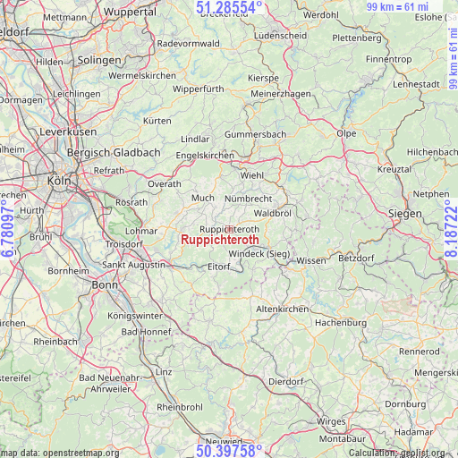
Ruppichteroth GPS coordinates[2]
50° 50' 37.212" North, 7° 29' 2.724" East
| Map corner | latitude | longitude |
|---|---|---|
| Upper-left | 51.28554°, | 6.78097° |
| Center: | 50.84367°, | 7.48409° |
| Lower-right: | 50.39758°, | 8.18722° |
| Map W x H: | 98.7×98.7 km | = 61.3×61.3mi |
| max Lat: | 55.01917° ⇑45% North |
| Ruppichteroth: | 50.84367° |
| min Lat: | ⇓55% South 47.40724° |
| min Long | Ruppichteroth | max Long |
| 5.92978° | 7.48409° | 14.98853° |
| W 12.9%⇐ | ⇒87.1% E |
Elevation
Elevation of Ruppichteroth is 169 m = 554 ft, and this is 80.1 m = 263 ft below average elevation for this country.
| Max E: |
1256 m = 4121 ft | 57.8% |
| Avg. | 249.1 m = 817 ft | |
| Ruppichteroth | 169 m = 554 ft | |
Min E: |
-5 m = -16 ft | 42.2% |
See also: Germany elevation on elevation.city.
Geographical zone
Ruppichteroth is located in North temperate zone (between Tropic of Cancer and the Arctic Circle). Distance of this North polar circle is 1747.9 km =1086.1 mi to North.| Distance of | km | miles | from Ruppichteroth |
|---|---|---|---|
| North Pole | 4353.8 | 2705.3 | to North |
| Arctic Circle | 1747.9 | 1086.1 | to North |
| Tropic Cancer | 3047.4 | 1893.6 | to South |
| Equator | 5653.3 | 3512.8 | to South |


Nearby cities:
15 places around Ruppichteroth: (largest is in red/bold)
• Bitzen
14.8 km =9.2 mi,  109°
109°
• Eitorf
8.9 km =5.5 mi,  195°
195°
• Forst
14.8 km =9.2 mi, 109°
• Fürthen
14.5 km =9 mi,  117°
117°
• Hasselbach
14.3 km =8.9 mi,  170°
170°
• Kircheib
15 km =9.3 mi,  186°
186°
• Much
8.8 km =5.5 mi,  319°
319°
• Niederirsen
13.2 km =8.2 mi,  141°
141°
• Nümbrecht
7.8 km =4.8 mi,  30°
30°
• Pracht
14.8 km =9.2 mi,  128°
128°
• Waldbröl
10 km =6.2 mi,  69°
69°
• Werkhausen
12.7 km =7.9 mi,  164°
164°
• Weyerbusch
14.9 km =9.3 mi, 161°
• Wiehl
12.7 km =7.9 mi,  21°
21°
• Ölsen
14.7 km =9.1 mi,  146°
146°
Sources, notices
• [Note1] Compared only with cities in Germany existing in our database
• [Src1] Map data: © OpenStreetMap contributors (CC-BY-SA)
• [Src2] Other city data from geonames.org with taken over terms of usage.
• [Src3] Geographical zone / Annual Mean Temperature by Robert A. Rohde @ Wikipedia
