Eil geodata
Eil (North Rhine-Westphalia) is a populated place; located in Germany in Europe/Berlin (GMT+2) time zone. With population of 8,849 people, there are 1814 cities with bigger population in this country. Compared to other cities in Germany, 55.9% of cities are located further ↓South; 92.6% of cities are located further →East and 78.3% of cities have higher elevation than Eil. Note1
Administrative division(s):
- Level 1: North Rhine-Westphalia
- Level 2: Regierungsbezirk Köln
- Level 3: Kreisfreie Stadt Köln
- Level 4: Köln


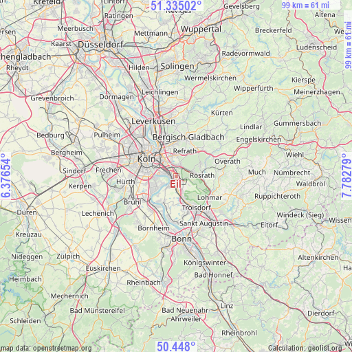
Eil GPS coordinates[2]
50° 53' 37.032" North, 7° 4' 46.812" East
| Map corner | latitude | longitude |
|---|---|---|
| Upper-left | 51.33502°, | 6.37654° |
| Center: | 50.89362°, | 7.07967° |
| Lower-right: | 50.448°, | 7.78279° |
| Map W x H: | 98.6×98.6 km | = 61.3×61.3mi |
| max Lat: | 55.01917° ⇑44.1% North |
| Eil: | 50.89362° |
| min Lat: | ⇓55.9% South 47.40724° |
| min Long | Eil | max Long |
| 5.92978° | 7.07967° | 14.98853° |
| W 7.4%⇐ | ⇒92.6% E |
Elevation
Elevation of Eil is 52 m = 171 ft, and this is 197.1 m = 647 ft below average elevation for this country.
| Max E: |
1256 m = 4121 ft | 78.3% |
| Avg. | 249.1 m = 817 ft | |
| Eil | 52 m = 171 ft | |
Min E: |
-5 m = -16 ft | 21.7% |
See also: Germany elevation on elevation.city.
Geographical zone
Eil is located in North temperate zone (between Tropic of Cancer and the Arctic Circle). Distance of this North polar circle is 1742.3 km =1082.6 mi to North.| Distance of | km | miles | from Eil |
|---|---|---|---|
| North Pole | 4348.2 | 2701.8 | to North |
| Arctic Circle | 1742.3 | 1082.6 | to North |
| Tropic Cancer | 3052.9 | 1897 | to South |
| Equator | 5658.8 | 3516.2 | to South |


Nearby cities:
15 places around Eil: (largest is in red/bold)
• Bayenthal
8.1 km =5 mi,  284°
284°
• Buchforst
8.2 km =5.1 mi,  320°
320°
• Buchheim
7.6 km =4.7 mi,  327°
327°
• Deutz
8.6 km =5.3 mi,  301°
301°
• Gremberghoven
1.6 km =1 mi, 304°
• Humboldtkolonie
7.3 km =4.5 mi,  305°
305°
• Höhenberg
5.2 km =3.2 mi, 328°
• Kalk
7.3 km =4.5 mi, 315°
• Niederkassel
9.2 km =5.7 mi,  198°
198°
• Ostheim
4.9 km =3 mi, 329°
• Poll
6.6 km =4.1 mi,  288°
288°
• Porz am Rhein
1.7 km =1.1 mi,  241°
241°
• Rath
3.5 km =2.2 mi,  15°
15°
• Rösrath
7.2 km =4.5 mi,  88°
88°
• Wahn-Heide
4.3 km =2.7 mi,  153°
153°
Sources, notices
• [Note1] Compared only with cities in Germany existing in our database
• [Src1] Map data: © OpenStreetMap contributors (CC-BY-SA)
• [Src2] Other city data from geonames.org with taken over terms of usage.
• [Src3] Geographical zone / Annual Mean Temperature by Robert A. Rohde @ Wikipedia
