Rath geodata
Rath (North Rhine-Westphalia) is a section of populated place; located in Germany in Europe/Berlin (GMT+2) time zone. With population of 11,000 people, there are 1504 cities with bigger population in this country. Compared to other cities in Germany, 56.6% of cities are located further ↓South; 92.4% of cities are located further →East and 77.3% of cities have higher elevation than Rath. Note1
Administrative division(s):
- Level 1: North Rhine-Westphalia
- Level 2: Regierungsbezirk Köln
- Level 3: Kreisfreie Stadt Köln
- Level 4: Köln


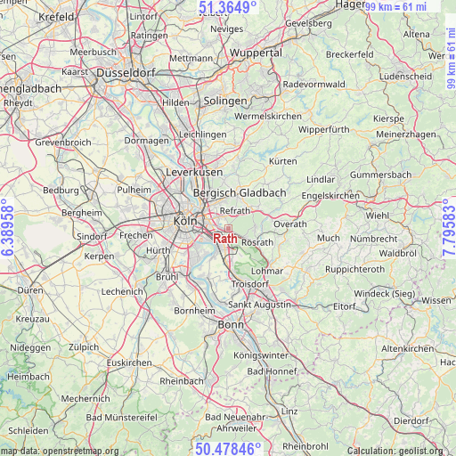
Rath GPS coordinates[2]
50° 55' 25.644" North, 7° 5' 33.72" East
| Map corner | latitude | longitude |
|---|---|---|
| Upper-left | 51.3649°, | 6.38958° |
| Center: | 50.92379°, | 7.0927° |
| Lower-right: | 50.47846°, | 7.79583° |
| Map W x H: | 98.6×98.6 km | = 61.3×61.3mi |
| max Lat: | 55.01917° ⇑43.4% North |
| Rath: | 50.92379° |
| min Lat: | ⇓56.6% South 47.40724° |
| min Long | Rath | max Long |
| 5.92978° | 7.0927° | 14.98853° |
| W 7.6%⇐ | ⇒92.4% E |
Elevation
Elevation of Rath is 55 m = 180 ft, and this is 194.1 m = 637 ft below average elevation for this country.
| Max E: |
1256 m = 4121 ft | 77.3% |
| Avg. | 249.1 m = 817 ft | |
| Rath | 55 m = 180 ft | |
Min E: |
-5 m = -16 ft | 22.7% |
See also: Germany elevation on elevation.city.
Geographical zone
Rath is located in North temperate zone (between Tropic of Cancer and the Arctic Circle). Distance of this North polar circle is 1739 km =1080.6 mi to North.| Distance of | km | miles | from Rath |
|---|---|---|---|
| North Pole | 4344.9 | 2699.8 | to North |
| Arctic Circle | 1739 | 1080.6 | to North |
| Tropic Cancer | 3056.3 | 1899.1 | to South |
| Equator | 5662.2 | 3518.3 | to South |


Nearby cities:
15 places around Rath: (largest is in red/bold)
• Bergisch Gladbach
7.4 km =4.6 mi,  22°
22°
• Buchforst
6.8 km =4.2 mi,  296°
296°
• Buchheim
5.9 km =3.7 mi, 301°
• Deutz
8.3 km =5.2 mi,  278°
278°
• Eil
3.5 km =2.2 mi,  195°
195°
• Gremberghoven
3.3 km =2.1 mi,  221°
221°
• Humboldtkolonie
6.9 km =4.3 mi, 277°
• Höhenberg
3.7 km =2.3 mi,  286°
286°
• Kalk
6.3 km =3.9 mi, 286°
• Mülheim
7.8 km =4.8 mi,  307°
307°
• Ostheim
3.5 km =2.2 mi, 283°
• Poll
7.3 km =4.5 mi,  260°
260°
• Porz am Rhein
4.8 km =3 mi,  210°
210°
• Rösrath
7 km =4.3 mi,  116°
116°
• Wahn-Heide
7.3 km =4.5 mi,  172°
172°
Sources, notices
• [Note1] Compared only with cities in Germany existing in our database
• [Src1] Map data: © OpenStreetMap contributors (CC-BY-SA)
• [Src2] Other city data from geonames.org with taken over terms of usage.
• [Src3] Geographical zone / Annual Mean Temperature by Robert A. Rohde @ Wikipedia
