Dörrmoschel geodata
Dörrmoschel (Rheinland-Pfalz) is a seat of a fourth-order administrative division; located in Germany in Europe/Berlin (GMT+2) time zone. With population of 173 people, there are 10578 cities with bigger population in this country. Compared to other cities in Germany, 73.5% of cities are located further ↑North; 82.1% of cities are located further →East and 73.5% of cities have lower elevation than Dörrmoschel. Note1


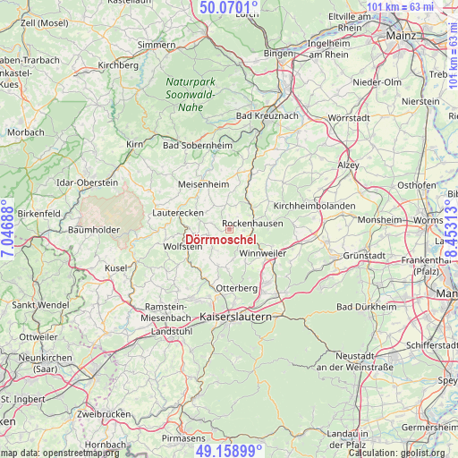
Dörrmoschel GPS coordinates[2]
49° 37' 0.012" North, 7° 45' 0" East
| Map corner | latitude | longitude |
|---|---|---|
| Upper-left | 50.0701°, | 7.04688° |
| Center: | 49.61667°, | 7.75° |
| Lower-right: | 49.15899°, | 8.45313° |
| Map W x H: | 101.3×101.3 km | = 62.9×62.9mi |
| max Lat: | 55.01917° ⇑73.5% North |
| Dörrmoschel: | 49.61667° |
| min Lat: | ⇓26.5% South 47.40724° |
| min Long | Dörrmoschel | max Long |
| 5.92978° | 7.75° | 14.98853° |
| W 17.9%⇐ | ⇒82.1% E |
Elevation
Elevation of Dörrmoschel is 386 m = 1266 ft, and this is 136.9 m = 449 ft above average elevation for this country.
| Max E: |
1256 m = 4121 ft | 26.5% |
| Dörrmoschel | 386 m 1266 ft | |
| Avg. | 249.1 m = 817 ft | |
Min E: |
-5 m = -16 ft | 73.5% |
See also: Germany elevation on elevation.city.
Geographical zone
Dörrmoschel is located in North temperate zone (between Tropic of Cancer and the Arctic Circle). Distance of this North polar circle is 1884.3 km =1170.8 mi to North.| Distance of | km | miles | from Dörrmoschel |
|---|---|---|---|
| North Pole | 4490.2 | 2790.1 | to North |
| Arctic Circle | 1884.3 | 1170.8 | to North |
| Tropic Cancer | 2910.9 | 1808.7 | to South |
| Equator | 5516.9 | 3428 | to South |


Nearby cities:
15 places around Dörrmoschel: (largest is in red/bold)
• Bisterschied
3.7 km =2.3 mi,  0°
0°
• Gehrweiler
3.9 km =2.4 mi,  162°
162°
• Gundersweiler
3 km =1.9 mi,  127°
127°
• Hefersweiler
5.1 km =3.2 mi,  248°
248°
• Imsweiler
4.1 km =2.5 mi,  117°
117°
• Katzenbach
5.3 km =3.3 mi,  53°
53°
• Niederkirchen
5.2 km =3.2 mi,  224°
224°
• Nußbach
4 km =2.5 mi,  297°
297°
• Ransweiler
5.7 km =3.5 mi,  12°
12°
• Rathskirchen
2.4 km =1.5 mi,  270°
270°
• Reichsthal
2.2 km =1.4 mi,  212°
212°
• Rockenhausen
5.3 km =3.3 mi,  74°
74°
• Schönborn
2.2 km =1.4 mi,  32°
32°
• Seelen
3 km =1.9 mi,  232°
232°
• Teschenmoschel
2.2 km =1.4 mi,  327°
327°
Sources, notices
• [Note1] Compared only with cities in Germany existing in our database
• [Src1] Map data: © OpenStreetMap contributors (CC-BY-SA)
• [Src2] Other city data from geonames.org with taken over terms of usage.
• [Src3] Geographical zone / Annual Mean Temperature by Robert A. Rohde @ Wikipedia
