Dahlenwarsleben geodata
Dahlenwarsleben (Saxony-Anhalt) is a populated place; located in Germany in Europe/Berlin (GMT+2) time zone. With population of 1,424 people, there are 6031 cities with bigger population in this country. Compared to other cities in Germany, 74% of cities are located further ↓South; 74.8% of cities are located further ←West and 74.7% of cities have higher elevation than Dahlenwarsleben. Note1


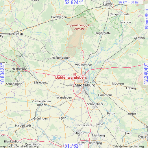
Dahlenwarsleben GPS coordinates[2]
52° 11' 42.684" North, 11° 32' 14.496" East
| Map corner | latitude | longitude |
|---|---|---|
| Upper-left | 52.6241°, | 10.83424° |
| Center: | 52.19519°, | 11.53736° |
| Lower-right: | 51.7621°, | 12.24049° |
| Map W x H: | 95.8×95.8 km | = 59.5×59.5mi |
| max Lat: | 55.01917° ⇑26% North |
| Dahlenwarsleben: | 52.19519° |
| min Lat: | ⇓74% South 47.40724° |
| min Long | Dahlenwarsleben | max Long |
| 5.92978° | 11.53736° | 14.98853° |
| W 74.8%⇐ | ⇒25.2% E |
Elevation
Elevation of Dahlenwarsleben is 64 m = 210 ft, and this is 185.1 m = 607 ft below average elevation for this country.
| Max E: |
1256 m = 4121 ft | 74.7% |
| Avg. | 249.1 m = 817 ft | |
| Dahlenwarsleben | 64 m = 210 ft | |
Min E: |
-5 m = -16 ft | 25.3% |
See also: Germany elevation on elevation.city.
Geographical zone
Dahlenwarsleben is located in North temperate zone (between Tropic of Cancer and the Arctic Circle). Distance of this North polar circle is 1597.6 km =992.7 mi to North.| Distance of | km | miles | from Dahlenwarsleben |
|---|---|---|---|
| North Pole | 4203.5 | 2611.9 | to North |
| Arctic Circle | 1597.6 | 992.7 | to North |
| Tropic Cancer | 3197.6 | 1986.9 | to South |
| Equator | 5803.6 | 3606.2 | to South |


Nearby cities:
15 places around Dahlenwarsleben: (largest is in red/bold)
• Barleben
5.5 km =3.4 mi,  82°
82°
• Diesdorf
7.4 km =4.6 mi,  165°
165°
• Ebendorf
2.8 km =1.7 mi,  112°
112°
• Groß Ammensleben
4.3 km =2.7 mi,  345°
345°
• Groß Santersleben
5.6 km =3.5 mi,  265°
265°
• Gutenswegen
5 km =3.1 mi,  321°
321°
• Hermsdorf
4.3 km =2.7 mi,  258°
258°
• Hohenwarsleben
3.1 km =1.9 mi,  234°
234°
• Irxleben
5 km =3.1 mi, 230°
• Jersleben
6.1 km =3.8 mi,  28°
28°
• Klein Ammensleben
2.8 km =1.7 mi,  335°
335°
• Meitzendorf
2.6 km =1.6 mi,  39°
39°
• Niederndodeleben
7.2 km =4.5 mi,  200°
200°
• Samswegen
7.5 km =4.7 mi,  12°
12°
• Vahldorf
7.3 km =4.5 mi, 339°
Sources, notices
• [Note1] Compared only with cities in Germany existing in our database
• [Src1] Map data: © OpenStreetMap contributors (CC-BY-SA)
• [Src2] Other city data from geonames.org with taken over terms of usage.
• [Src3] Geographical zone / Annual Mean Temperature by Robert A. Rohde @ Wikipedia
