Vahldorf geodata
Vahldorf (Saxony-Anhalt) is a populated place; located in Germany in Europe/Berlin (GMT+2) time zone. With population of 562 people, there are 9018 cities with bigger population in this country. Compared to other cities in Germany, 74.7% of cities are located further ↓South; 74.2% of cities are located further ←West and 78.9% of cities have higher elevation than Vahldorf. Note1


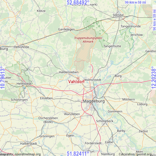
Vahldorf GPS coordinates[2]
52° 15' 23.76" North, 11° 29' 57.3" East
| Map corner | latitude | longitude |
|---|---|---|
| Upper-left | 52.68492°, | 10.79613° |
| Center: | 52.2566°, | 11.49925° |
| Lower-right: | 51.82411°, | 12.20238° |
| Map W x H: | 95.7×95.7 km | = 59.5×59.5mi |
| max Lat: | 55.01917° ⇑25.3% North |
| Vahldorf: | 52.2566° |
| min Lat: | ⇓74.7% South 47.40724° |
| min Long | Vahldorf | max Long |
| 5.92978° | 11.49925° | 14.98853° |
| W 74.2%⇐ | ⇒25.8% E |
Elevation
Elevation of Vahldorf is 50 m = 164 ft, and this is 199.1 m = 653 ft below average elevation for this country.
| Max E: |
1256 m = 4121 ft | 78.9% |
| Avg. | 249.1 m = 817 ft | |
| Vahldorf | 50 m = 164 ft | |
Min E: |
-5 m = -16 ft | 21.1% |
See also: Germany elevation on elevation.city.
Geographical zone
Vahldorf is located in North temperate zone (between Tropic of Cancer and the Arctic Circle). Distance of this North polar circle is 1590.8 km =988.5 mi to North.| Distance of | km | miles | from Vahldorf |
|---|---|---|---|
| North Pole | 4196.7 | 2607.7 | to North |
| Arctic Circle | 1590.8 | 988.5 | to North |
| Tropic Cancer | 3204.5 | 1991.2 | to South |
| Equator | 5810.4 | 3610.4 | to South |


Nearby cities:
15 places around Vahldorf: (largest is in red/bold)
• Dahlenwarsleben
7.3 km =4.5 mi,  159°
159°
• Groß Ammensleben
3.1 km =1.9 mi,  149°
149°
• Groß Santersleben
7.9 km =4.9 mi,  202°
202°
• Gutenswegen
3 km =1.9 mi,  189°
189°
• Haldensleben I
7.1 km =4.4 mi,  300°
300°
• Hermsdorf
7.9 km =4.9 mi, 191°
• Hillersleben
3.2 km =2 mi,  333°
333°
• Hohenwarsleben
8.6 km =5.3 mi,  179°
179°
• Jersleben
5.7 km =3.5 mi,  104°
104°
• Klein Ammensleben
4.5 km =2.8 mi, 161°
• Meitzendorf
6.4 km =4 mi,  138°
138°
• Neuenhofe
5.7 km =3.5 mi, 334°
• Rottmersleben
8.4 km =5.2 mi,  234°
234°
• Samswegen
4.3 km =2.7 mi,  84°
84°
• Schackensleben
8.7 km =5.4 mi,  218°
218°
Sources, notices
• [Note1] Compared only with cities in Germany existing in our database
• [Src1] Map data: © OpenStreetMap contributors (CC-BY-SA)
• [Src2] Other city data from geonames.org with taken over terms of usage.
• [Src3] Geographical zone / Annual Mean Temperature by Robert A. Rohde @ Wikipedia
