Buhlenberg geodata
Buhlenberg (Rheinland-Pfalz) is a seat of a fourth-order administrative division; located in Germany in Europe/Berlin (GMT+2) time zone. With population of 535 people, there are 9166 cities with bigger population in this country. Compared to other cities in Germany, 72.4% of cities are located further ↑North; 92.1% of cities are located further →East and 87.6% of cities have lower elevation than Buhlenberg. Note1
Administrative division(s):
- Level 1: Rheinland-Pfalz
- Level 3: Landkreis Birkenfeld
- Level 4: Buhlenberg


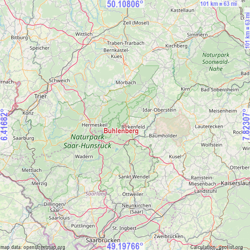
Buhlenberg GPS coordinates[2]
49° 39' 17.964" North, 7° 7' 11.82" East
| Map corner | latitude | longitude |
|---|---|---|
| Upper-left | 50.10806°, | 6.41682° |
| Center: | 49.65499°, | 7.11995° |
| Lower-right: | 49.19766°, | 7.82307° |
| Map W x H: | 101.2×101.2 km | = 62.9×62.9mi |
| max Lat: | 55.01917° ⇑72.4% North |
| Buhlenberg: | 49.65499° |
| min Lat: | ⇓27.6% South 47.40724° |
| min Long | Buhlenberg | max Long |
| 5.92978° | 7.11995° | 14.98853° |
| W 7.9%⇐ | ⇒92.1% E |
Elevation
Elevation of Buhlenberg is 490 m = 1608 ft, and this is 240.9 m = 790 ft above average elevation for this country.
| Max E: |
1256 m = 4121 ft | 12.4% |
| Buhlenberg | 490 m 1608 ft | |
| Avg. | 249.1 m = 817 ft | |
Min E: |
-5 m = -16 ft | 87.6% |
See also: Germany elevation on elevation.city.
Geographical zone
Buhlenberg is located in North temperate zone (between Tropic of Cancer and the Arctic Circle). Distance of this North polar circle is 1880.1 km =1168.2 mi to North.| Distance of | km | miles | from Buhlenberg |
|---|---|---|---|
| North Pole | 4485.9 | 2787.4 | to North |
| Arctic Circle | 1880.1 | 1168.2 | to North |
| Tropic Cancer | 2915.2 | 1811.4 | to South |
| Equator | 5521.1 | 3430.7 | to South |


Nearby cities:
15 places around Buhlenberg: (largest is in red/bold)
• Abentheuer
1.5 km =0.9 mi,  248°
248°
• Achtelsbach
3.9 km =2.4 mi,  213°
213°
• Birkenfeld
3.4 km =2.1 mi,  94°
94°
• Brücken
2.4 km =1.5 mi,  185°
185°
• Börfink
4.1 km =2.5 mi,  320°
320°
• Dambach
2.6 km =1.6 mi,  158°
158°
• Dienstweiler
5.2 km =3.2 mi,  117°
117°
• Ellenberg
2.2 km =1.4 mi,  104°
104°
• Ellweiler
4.8 km =3 mi,  153°
153°
• Gollenberg
3.6 km =2.2 mi,  68°
68°
• Hattgenstein
5.5 km =3.4 mi,  23°
23°
• Meckenbach
4.5 km =2.8 mi,  198°
198°
• Oberhambach
4.6 km =2.9 mi,  46°
46°
• Rinzenberg
3.3 km =2.1 mi, 16°
• Schmißberg
5.9 km =3.7 mi,  77°
77°
Sources, notices
• [Note1] Compared only with cities in Germany existing in our database
• [Src1] Map data: © OpenStreetMap contributors (CC-BY-SA)
• [Src2] Other city data from geonames.org with taken over terms of usage.
• [Src3] Geographical zone / Annual Mean Temperature by Robert A. Rohde @ Wikipedia
