Abentheuer geodata
Abentheuer (Rheinland-Pfalz) is a seat of a fourth-order administrative division; located in Germany in Europe/Berlin (GMT+2) time zone. With population of 465 people, there are 9490 cities with bigger population in this country. Compared to other cities in Germany, 72.6% of cities are located further ↑North; 92.4% of cities are located further →East and 78.5% of cities have lower elevation than Abentheuer. Note1
Administrative division(s):
- Level 1: Rheinland-Pfalz
- Level 3: Landkreis Birkenfeld
- Level 4: Abentheuer


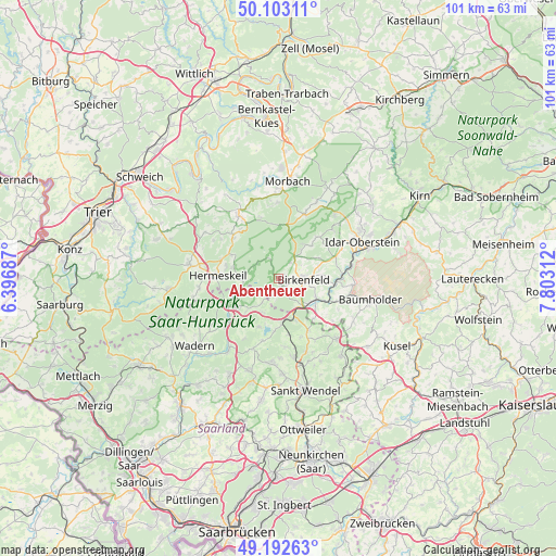
Abentheuer GPS coordinates[2]
49° 39' 0" North, 7° 6' 0" East
| Map corner | latitude | longitude |
|---|---|---|
| Upper-left | 50.10311°, | 6.39687° |
| Center: | 49.65°, | 7.1° |
| Lower-right: | 49.19263°, | 7.80312° |
| Map W x H: | 101.2×101.2 km | = 62.9×62.9mi |
| max Lat: | 55.01917° ⇑72.6% North |
| Abentheuer: | 49.65° |
| min Lat: | ⇓27.4% South 47.40724° |
| min Long | Abentheuer | max Long |
| 5.92978° | 7.1° | 14.98853° |
| W 7.6%⇐ | ⇒92.4% E |
Elevation
Elevation of Abentheuer is 423 m = 1388 ft, and this is 173.9 m = 571 ft above average elevation for this country.
| Max E: |
1256 m = 4121 ft | 21.5% |
| Abentheuer | 423 m 1388 ft | |
| Avg. | 249.1 m = 817 ft | |
Min E: |
-5 m = -16 ft | 78.5% |
See also: Germany elevation on elevation.city.
Geographical zone
Abentheuer is located in North temperate zone (between Tropic of Cancer and the Arctic Circle). Distance of this North polar circle is 1880.6 km =1168.6 mi to North.| Distance of | km | miles | from Abentheuer |
|---|---|---|---|
| North Pole | 4486.5 | 2787.8 | to North |
| Arctic Circle | 1880.6 | 1168.6 | to North |
| Tropic Cancer | 2914.6 | 1811 | to South |
| Equator | 5520.6 | 3430.3 | to South |


Nearby cities:
15 places around Abentheuer: (largest is in red/bold)
• Achtelsbach
2.8 km =1.7 mi,  194°
194°
• Birkenfeld
4.8 km =3 mi,  86°
86°
• Brücken
2.2 km =1.4 mi,  147°
147°
• Buhlenberg
1.5 km =0.9 mi,  68°
68°
• Börfink
3.9 km =2.4 mi,  342°
342°
• Dambach
3 km =1.9 mi,  127°
127°
• Dienstweiler
6.3 km =3.9 mi,  107°
107°
• Ellenberg
3.6 km =2.2 mi, 90°
• Ellweiler
5.2 km =3.2 mi,  135°
135°
• Gollenberg
5.1 km =3.2 mi, 68°
• Hattgenstein
6.6 km =4.1 mi,  32°
32°
• Meckenbach
3.7 km =2.3 mi,  180°
180°
• Neuhütten
6.2 km =3.9 mi,  262°
262°
• Oberhambach
6.1 km =3.8 mi,  52°
52°
• Rinzenberg
4.4 km =2.7 mi, 32°
Sources, notices
• [Note1] Compared only with cities in Germany existing in our database
• [Src1] Map data: © OpenStreetMap contributors (CC-BY-SA)
• [Src2] Other city data from geonames.org with taken over terms of usage.
• [Src3] Geographical zone / Annual Mean Temperature by Robert A. Rohde @ Wikipedia
