Büchenbeuren geodata
Büchenbeuren (Rheinland-Pfalz) is a seat of a fourth-order administrative division; located in Germany in Europe/Berlin (GMT+2) time zone. With population of 1,647 people, there are 5610 cities with bigger population in this country. Compared to other cities in Germany, 65.8% of cities are located further ↑North; 90.4% of cities are located further →East and 82% of cities have lower elevation than Büchenbeuren. Note1
Administrative division(s):
- Level 1: Rheinland-Pfalz
- Level 3: Rhein-Hunsrück-Kreis
- Level 4: Büchenbeuren


Büchenbeuren GPS coordinates[2]
49° 55' 15.492" North, 7° 16' 47.964" East
| Map corner | latitude | longitude |
|---|---|---|
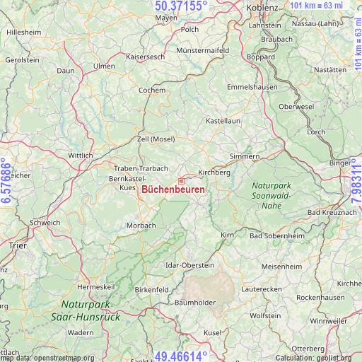
| Upper-left | 50.37155°, | 6.57686° |
| Center: | 49.92097°, | 7.27999° |
| Lower-right: | 49.46614°, | 7.98311° |
| Map W x H: | 100.7×100.7 km | = 62.6×62.6mi |
| max Lat: | 55.01917° ⇑65.8% North |
| Büchenbeuren: | 49.92097° |
| min Lat: | ⇓34.2% South 47.40724° |
| min Long | Büchenbeuren | max Long |
| 5.92978° | 7.27999° | 14.98853° |
| W 9.6%⇐ | ⇒90.4% E |
Elevation
Elevation of Büchenbeuren is 446 m = 1463 ft, and this is 196.9 m = 646 ft above average elevation for this country.
| Max E: |
1256 m = 4121 ft | 18% |
| Büchenbeuren | 446 m 1463 ft | |
| Avg. | 249.1 m = 817 ft | |
Min E: |
-5 m = -16 ft | 82% |
See also: Germany elevation on elevation.city.
Geographical zone
Büchenbeuren is located in North temperate zone (between Tropic of Cancer and the Arctic Circle). Distance of this North polar circle is 1850.5 km =1149.8 mi to North.| Distance of | km | miles | from Büchenbeuren |
|---|---|---|---|
| North Pole | 4456.4 | 2769.1 | to North |
| Arctic Circle | 1850.5 | 1149.8 | to North |
| Tropic Cancer | 2944.8 | 1829.8 | to South |
| Equator | 5550.7 | 3449 | to South |


Nearby cities:
15 places around Büchenbeuren: (largest is in red/bold)
• Bärenbach
3.5 km =2.2 mi,  23°
23°
• Dill
5 km =3.1 mi,  95°
95°
• Hahn
5.2 km =3.2 mi,  349°
349°
• Horbruch
5.4 km =3.4 mi,  218°
218°
• Krummenau
4.3 km =2.7 mi,  192°
192°
• Laufersweiler
3.3 km =2.1 mi,  146°
146°
• Lautzenhausen
1.7 km =1.1 mi,  325°
325°
• Lötzbeuren
4.7 km =2.9 mi,  286°
286°
• Niedersohren
4.1 km =2.5 mi,  70°
70°
• Niederweiler
2.3 km =1.4 mi,  174°
174°
• Raversbeuren
4.6 km =2.9 mi,  314°
314°
• Schwerbach
5.5 km =3.4 mi,  114°
114°
• Sohren
3 km =1.9 mi,  62°
62°
• Sohrschied
5.5 km =3.4 mi, 114°
• Wahlenau
3.2 km =2 mi, 222°
Sources, notices
• [Note1] Compared only with cities in Germany existing in our database
• [Src1] Map data: © OpenStreetMap contributors (CC-BY-SA)
• [Src2] Other city data from geonames.org with taken over terms of usage.
• [Src3] Geographical zone / Annual Mean Temperature by Robert A. Rohde @ Wikipedia
