Laufersweiler geodata
Laufersweiler (Rheinland-Pfalz) is a seat of a fourth-order administrative division; located in Germany in Europe/Berlin (GMT+2) time zone. With population of 847 people, there are 7717 cities with bigger population in this country. Compared to other cities in Germany, 66.6% of cities are located further ↑North; 89.8% of cities are located further →East and 80.2% of cities have lower elevation than Laufersweiler. Note1
Administrative division(s):
- Level 1: Rheinland-Pfalz
- Level 3: Rhein-Hunsrück-Kreis
- Level 4: Laufersweiler


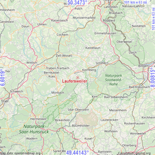
Laufersweiler GPS coordinates[2]
49° 53' 47.364" North, 7° 18' 18.072" East
| Map corner | latitude | longitude |
|---|---|---|
| Upper-left | 50.3473°, | 6.6019° |
| Center: | 49.89649°, | 7.30502° |
| Lower-right: | 49.44143°, | 8.00815° |
| Map W x H: | 100.7×100.7 km | = 62.6×62.6mi |
| max Lat: | 55.01917° ⇑66.6% North |
| Laufersweiler: | 49.89649° |
| min Lat: | ⇓33.4% South 47.40724° |
| min Long | Laufersweiler | max Long |
| 5.92978° | 7.30502° | 14.98853° |
| W 10.2%⇐ | ⇒89.8% E |
Elevation
Elevation of Laufersweiler is 434 m = 1424 ft, and this is 184.9 m = 607 ft above average elevation for this country.
| Max E: |
1256 m = 4121 ft | 19.8% |
| Laufersweiler | 434 m 1424 ft | |
| Avg. | 249.1 m = 817 ft | |
Min E: |
-5 m = -16 ft | 80.2% |
See also: Germany elevation on elevation.city.
Geographical zone
Laufersweiler is located in North temperate zone (between Tropic of Cancer and the Arctic Circle). Distance of this North polar circle is 1853.2 km =1151.5 mi to North.| Distance of | km | miles | from Laufersweiler |
|---|---|---|---|
| North Pole | 4459.1 | 2770.8 | to North |
| Arctic Circle | 1853.2 | 1151.5 | to North |
| Tropic Cancer | 2942.1 | 1828.1 | to South |
| Equator | 5548 | 3447.4 | to South |


Nearby cities:
15 places around Laufersweiler: (largest is in red/bold)
• Büchenbeuren
3.3 km =2.1 mi,  326°
326°
• Dill
3.9 km =2.4 mi,  55°
55°
• Gösenroth
2.5 km =1.6 mi,  125°
125°
• Horbruch
5.3 km =3.3 mi,  254°
254°
• Krummenau
3.1 km =1.9 mi,  241°
241°
• Lautzenhausen
4.9 km =3 mi, 326°
• Niedersohren
4.6 km =2.9 mi,  26°
26°
• Niederweiler
1.6 km =1 mi,  284°
284°
• Oberkirn
4.7 km =2.9 mi,  108°
108°
• Rhaunen
4.5 km =2.8 mi,  143°
143°
• Schwerbach
3.2 km =2 mi,  83°
83°
• Sohren
4.2 km =2.6 mi,  11°
11°
• Sohrschied
3.2 km =2 mi, 83°
• Wahlenau
4 km =2.5 mi, 275°
• Weitersbach
3.4 km =2.1 mi,  165°
165°
Sources, notices
• [Note1] Compared only with cities in Germany existing in our database
• [Src1] Map data: © OpenStreetMap contributors (CC-BY-SA)
• [Src2] Other city data from geonames.org with taken over terms of usage.
• [Src3] Geographical zone / Annual Mean Temperature by Robert A. Rohde @ Wikipedia
