Bickendorf geodata
Bickendorf (Rheinland-Pfalz) is a seat of a fourth-order administrative division; located in Germany in Europe/Berlin (GMT+2) time zone. With population of 524 people, there are 9231 cities with bigger population in this country. Compared to other cities in Germany, 63% of cities are located further ↑North; 97.8% of cities are located further →East and 61.7% of cities have lower elevation than Bickendorf. Note1
Administrative division(s):
- Level 1: Rheinland-Pfalz
- Level 3: Eifelkreis Bitburg-Prüm
- Level 4: Bickendorf


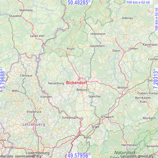
Bickendorf GPS coordinates[2]
50° 1' 59.988" North, 6° 30' 0" East
| Map corner | latitude | longitude |
|---|---|---|
| Upper-left | 50.48285°, | 5.79688° |
| Center: | 50.03333°, | 6.5° |
| Lower-right: | 49.57956°, | 7.20313° |
| Map W x H: | 100.4×100.4 km | = 62.4×62.4mi |
| max Lat: | 55.01917° ⇑63% North |
| Bickendorf: | 50.03333° |
| min Lat: | ⇓37% South 47.40724° |
| min Long | Bickendorf | max Long |
| 5.92978° | 6.5° | 14.98853° |
| W 2.2%⇐ | ⇒97.8% E |
Elevation
Elevation of Bickendorf is 300 m = 984 ft, and this is 50.9 m = 167 ft above average elevation for this country.
| Max E: |
1256 m = 4121 ft | 38.3% |
| Bickendorf | 300 m 984 ft | |
| Avg. | 249.1 m = 817 ft | |
Min E: |
-5 m = -16 ft | 61.7% |
See also: Germany elevation on elevation.city.
Geographical zone
Bickendorf is located in North temperate zone (between Tropic of Cancer and the Arctic Circle). Distance of this North polar circle is 1838 km =1142.1 mi to North.| Distance of | km | miles | from Bickendorf |
|---|---|---|---|
| North Pole | 4443.9 | 2761.3 | to North |
| Arctic Circle | 1838 | 1142.1 | to North |
| Tropic Cancer | 2957.3 | 1837.6 | to South |
| Equator | 5563.2 | 3456.8 | to South |


Nearby cities:
15 places around Bickendorf: (largest is in red/bold)
• Biersdorf
4.1 km =2.5 mi,  239°
239°
• Ehlenz
2.2 km =1.4 mi,  291°
291°
• Etteldorf
4.8 km =3 mi,  90°
90°
• Fließem
3.2 km =2 mi,  110°
110°
• Heilenbach
4.4 km =2.7 mi,  327°
327°
• Ließem
1.2 km =0.7 mi,  270°
270°
• Malbergweich
4.6 km =2.9 mi,  57°
57°
• Nattenheim
2.2 km =1.4 mi,  147°
147°
• Niederweiler
3.6 km =2.2 mi, 270°
• Oberweiler
4 km =2.5 mi,  297°
297°
• Rittersdorf
3.7 km =2.3 mi,  180°
180°
• Schleid
3.9 km =2.4 mi,  342°
342°
• Seffern
3.7 km =2.3 mi,  0°
0°
• Sefferweich
3.9 km =2.4 mi,  17°
17°
• Wiersdorf
5.1 km =3.2 mi,  223°
223°
Sources, notices
• [Note1] Compared only with cities in Germany existing in our database
• [Src1] Map data: © OpenStreetMap contributors (CC-BY-SA)
• [Src2] Other city data from geonames.org with taken over terms of usage.
• [Src3] Geographical zone / Annual Mean Temperature by Robert A. Rohde @ Wikipedia
