Berkoth geodata
Berkoth (Rheinland-Pfalz) is a seat of a fourth-order administrative division; located in Germany in Europe/Berlin (GMT+2) time zone. With population of 97 people, there are 10845 cities with bigger population in this country. Compared to other cities in Germany, 62.6% of cities are located further ↑North; 99% of cities are located further →East and 90.2% of cities have lower elevation than Berkoth. Note1
Administrative division(s):
- Level 1: Rheinland-Pfalz
- Level 3: Eifelkreis Bitburg-Prüm
- Level 4: Berkoth


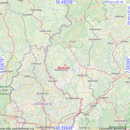
Berkoth GPS coordinates[2]
50° 2' 38.976" North, 6° 20' 23.676" East
| Map corner | latitude | longitude |
|---|---|---|
| Upper-left | 50.49358°, | 5.63679° |
| Center: | 50.04416°, | 6.33991° |
| Lower-right: | 49.59049°, | 7.04304° |
| Map W x H: | 100.4×100.4 km | = 62.4×62.4mi |
| max Lat: | 55.01917° ⇑62.6% North |
| Berkoth: | 50.04416° |
| min Lat: | ⇓37.4% South 47.40724° |
| min Long | Berkoth | max Long |
| 5.92978° | 6.33991° | 14.98853° |
| W 1%⇐ | ⇒99% E |
Elevation
Elevation of Berkoth is 516 m = 1693 ft, and this is 266.9 m = 876 ft above average elevation for this country.
| Max E: |
1256 m = 4121 ft | 9.8% |
| Berkoth | 516 m 1693 ft | |
| Avg. | 249.1 m = 817 ft | |
Min E: |
-5 m = -16 ft | 90.2% |
See also: Germany elevation on elevation.city.
Geographical zone
Berkoth is located in North temperate zone (between Tropic of Cancer and the Arctic Circle). Distance of this North polar circle is 1836.8 km =1141.3 mi to North.| Distance of | km | miles | from Berkoth |
|---|---|---|---|
| North Pole | 4442.7 | 2760.6 | to North |
| Arctic Circle | 1836.8 | 1141.3 | to North |
| Tropic Cancer | 2958.5 | 1838.3 | to South |
| Equator | 5564.4 | 3457.6 | to South |


Nearby cities:
15 places around Berkoth: (largest is in red/bold)
• Altscheid
5.3 km =3.3 mi,  125°
125°
• Emmelbaum
5.3 km =3.3 mi,  277°
277°
• Fischbach-Oberraden
4.9 km =3 mi,  185°
185°
• Heilbach
4.1 km =2.5 mi, 279°
• Krautscheid
2.5 km =1.6 mi,  349°
349°
• Lambertsberg
5.3 km =3.3 mi,  35°
35°
• Lauperath
4.4 km =2.7 mi, 353°
• Mauel
5 km =3.1 mi,  59°
59°
• Niederpierscheid
4.8 km =3 mi,  23°
23°
• Oberpierscheid
3.1 km =1.9 mi, 37°
• Plascheid
4.2 km =2.6 mi,  253°
253°
• Scheuern
4.2 km =2.6 mi,  223°
223°
• Uppershausen
2.1 km =1.3 mi,  234°
234°
• Utscheid
5 km =3.1 mi,  171°
171°
• Weidingen
4.4 km =2.7 mi, 134°
Sources, notices
• [Note1] Compared only with cities in Germany existing in our database
• [Src1] Map data: © OpenStreetMap contributors (CC-BY-SA)
• [Src2] Other city data from geonames.org with taken over terms of usage.
• [Src3] Geographical zone / Annual Mean Temperature by Robert A. Rohde @ Wikipedia
